Category:Frankfurter Straße 49 (Offenbach am Main)
Jump to navigation
Jump to search
This is the category of the Hessian Kulturdenkmal (cultural monument) with the ID 78172 (Wikidata)
|
| Object location | | View all coordinates using: OpenStreetMap |
|---|
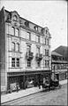
Deutsch: Frankfurter Straße 49, Offenbach am Main. Wohn- und Geschäftshaus von 1903.
·  | |||||
| Upload media | |||||
| Instance of | |||||
|---|---|---|---|---|---|
| Location | Offenbach am Main, Darmstadt Government Region, Hesse, Germany | ||||
| Heritage designation | |||||
 | |||||
Media in category "Frankfurter Straße 49 (Offenbach am Main)"
The following 3 files are in this category, out of 3 total.
-
 Frankfurter Strasse 49 Offenbach am Main 01.jpg 2,592 × 1,728; 841 KB
-
 OF Frankf 1905 PH1.jpg 1,540 × 2,380; 1.67 MB
-
 OF Frankf 1905 PH1.tiff 1,540 × 2,380; 3.14 MB
