Category:Francis Scott Key Bridge (Baltimore)
Jump to navigation
Jump to search
collapsed toll bridge in Baltimore, Maryland .jpg) _-_cropped.jpg)   _as_it_crosses_the_Francis_Scott_Key_Bridge_over_the_Patapsco_River_in_Baltimore_City,_Maryland.jpg) | |||||
| Upload media | |||||
| Instance of | |||||
|---|---|---|---|---|---|
| Named after | |||||
| Made from material | |||||
| Location |
| ||||
| Owned by | |||||
| Operator | |||||
| Maintained by | |||||
| Crosses | |||||
| Carries | |||||
| Inception |
| ||||
| Date of official opening |
| ||||
| Dissolved, abolished or demolished date |
| ||||
| Significant event | |||||
| Length |
| ||||
| Elevation above sea level |
| ||||
| Cause of destruction |
| ||||
| Cost |
| ||||
| Different from | |||||
| official website | |||||
 | |||||
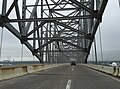
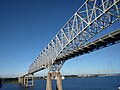
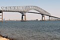
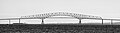
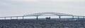
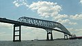
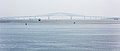
English: The Francis Scott Key Bridge, normally called the Key Bridge and also called the Outer Harbor Bridge, was a toll bridge in Maryland. It carried Interstate 695/Maryland Route 695 across the Patapsco River, from between Dundalk and Egdemere in Baltimore County, to Hawkins Point within the city of Baltimore.
It collapsed on March 26, 2024 after a support pier was struck by a container ship.
Subcategories
This category has the following 3 subcategories, out of 3 total.
Media in category "Francis Scott Key Bridge (Baltimore)"
The following 60 files are in this category, out of 60 total.
-

-

-

-

-

-
-

-

-

-

-

-
-
 20190202 Francis Scott Key Bridge (Baltimore) at sunset.jpg 3,915 × 1,934; 698 KB
-
 Baltimore Navy Week 2012 120613-N-FV870-996.jpg 4,288 × 2,848; 2.26 MB
-
 Baltimore's Francis Scott Key Bridge - 52091439189.jpg 3,827 × 2,871; 1.48 MB
-
 Baltimore's Francis Scott Key Bridge - 52617551139.jpg 4,608 × 3,072; 2.96 MB
-
 Coast Guard Cutter Eagle arrives in Baltimore for OpSail 2012 120614-G-HA574-002.jpg 4,256 × 2,832; 6.81 MB
-
Crossing the Key Bridge (Baltimore).webm 3 min 19 s, 1,920 × 1,080; 144.9 MB
-
 CuauhtémocSailabration.JPG 3,648 × 2,048; 693 KB
-
 Driving the Francis Scott Key bridge.jpg 2,037 × 1,482; 2.19 MB
-

-
 Fort Carroll Key Bridge Aug2010.jpg 830 × 553; 82 KB
-
 FortSmallwoodParkMaryland.jpg 600 × 450; 417 KB
-
 Francis scott key bridge (2019).jpg 5,416 × 3,610; 9.89 MB
-
 Francis Scott Key Bridge (Baltimore).jpg 612 × 612; 126 KB
-
 Francis Scott Key Bridge - 2010.JPG 1,600 × 1,069; 272 KB
-
 Francis Scott Key Bridge at Baltimore in September 2014.JPG 2,400 × 1,597; 1.95 MB
-
 Francis Scott Key Bridge at Sunrise.jpg 3,504 × 2,336; 3.44 MB
-
 Francis Scott Key Bridge Baltimore Maryland.jpg 6,273 × 3,058; 8.38 MB
-
 Francis Scott Key Bridge Eastern View.jpg 3,358 × 2,517; 4.04 MB
-
 Francis Scott Key Bridge from Fort McHenry.jpg 3,433 × 1,608; 454 KB
-
 Francis Scott Key Bridge I-695 Aerial.jpg 2,400 × 3,600; 1.92 MB
-
 Francis Scott Key Bridge in Baltimore, MD.jpg 4,500 × 1,234; 3.51 MB
-
 FRancis Scott Key Bridge MD1.jpg 3,785 × 1,261; 3.17 MB
-
 Francis Scott Key Bridge southern truss support.jpg 1,302 × 1,114; 338 KB
-
 Francis Scott Key Bridge.jpg 3,008 × 2,000; 3.01 MB
-
 Francis scott key bridge.jpg 2,816 × 1,584; 1.15 MB
-
 GloriaSailabration.JPG 3,648 × 2,048; 723 KB
-
 Herbert A. Wagner Generating Station aerial.jpg 3,658 × 2,013; 6.19 MB
-
 HessenSailabration1.JPG 3,648 × 2,048; 729 KB
-
 I-695 outer approaching Key Bridge, May 2023.jpg 3,039 × 1,919; 1.37 MB
-
 I-695 outer, mp 47.6, May 2023.jpg 3,312 × 2,219; 1.47 MB
-
 ISS006-E-35656 - View of Maryland.jpg 3,032 × 2,064; 2.25 MB
-
 ISS033-E-14186 - View of Maryland.jpg 1,440 × 960; 1.01 MB
-
 ISS048-E-16946 - View of Maryland.jpg 4,928 × 3,280; 2.3 MB
-
 KeyBridge.Baltimore.MD.jpg 845 × 634; 155 KB
-
 MJK48051 Francis Scott Key Bridge (Baltimore) - cropped.jpg 5,593 × 1,312; 2.76 MB
-
 MJK48051 Francis Scott Key Bridge (Baltimore).jpg 5,593 × 2,397; 5.05 MB
-
 MJK48052 Francis Scott Key Bridge (Baltimore).jpg 5,562 × 3,129; 3.52 MB
-
 NOAA 12281.pdf 6,106 × 4,825; 4.78 MB
-
 Passing under Baltimore's Francis Scott Key Bridge.jpg 4,608 × 3,072; 3.3 MB
-
 Riverside Generating Station 2.jpg 1,600 × 1,200; 514 KB
-

-
 The Francis Scott Key Bridge (Baltimore).jpg 4,981 × 3,321; 6.5 MB
-
 The francis scott key bridge.jpg 2,040 × 1,452; 1.7 MB
-

-
 View of Baltimore Harbor from Fort McHenry 11.JPG 4,272 × 2,848; 2.51 MB
-
 View of Baltimore Harbor from Fort McHenry 12.JPG 4,272 × 2,848; 2.78 MB
-
 View of Baltimore Harbor from Fort McHenry 9.JPG 4,272 × 2,848; 4.37 MB
-
 WB I-695 @ Francis Scott Key Bridge.jpg 3,648 × 2,736; 2.06 MB
_as_it_begins_to_cross_the_Francis_Scott_Key_Bridge_over_the_Patapsco_River_in_Dundalk,_Baltimore_County,_Maryland.jpg)
_as_it_crosses_the_Francis_Scott_Key_Bridge_over_the_Patapsco_River_in_Dundalk,_Baltimore_County,_Maryland.jpg)
_as_it_crosses_the_Francis_Scott_Key_Bridge_over_the_Patapsco_River_in_Dundalk,_Baltimore_County,_Maryland.jpg)
_as_it_crosses_the_Francis_Scott_Key_Bridge_over_the_Patapsco_River_in_Dundalk,_Baltimore_County,_Maryland.jpg)
_as_it_crosses_the_Francis_Scott_Key_Bridge_over_the_Patapsco_River_in_Baltimore_City,_Maryland.jpg)
_as_it_crosses_the_Francis_Scott_Key_Bridge_over_the_Patapsco_River_in_Baltimore_City,_Maryland.jpg)
_as_it_crosses_the_Francis_Scott_Key_Bridge_over_the_Patapsco_River_in_Baltimore_City,_Maryland.jpg)
_as_it_crosses_the_Francis_Scott_Key_Bridge_over_the_Patapsco_River_in_Baltimore_City,_Maryland.jpg)
_as_it_crosses_the_Francis_Scott_Key_Bridge_over_the_Patapsco_River_in_Dundalk,_Baltimore_County,_Maryland.jpg)
_along_the_border_of_Baltimore_City,_Maryland_and_Dundalk,_Baltimore_County,_Maryland.jpg)
_along_the_border_of_Baltimore_City,_Maryland_and_Dundalk,_Baltimore_County,_Maryland.jpg)
_at_sunset.jpg)


.jpg)
.jpg)


.jpg)
.jpg)


_sails_under_the_Francis_Scott_Key_Bridge_in_support_of_Baltimore%27s_Star-Spangled_Spectacular_-_140910-N-CE241-019.jpg)


Categories:
- Hawkins Point, Baltimore
- Bridges in Baltimore
- Dundalk, Maryland
- Sparrows Point, Maryland
- Interstate 695 in Baltimore, Maryland
- Interstate 695 in Baltimore County, Maryland
- 100-149-meter-tall structures in Maryland
- Destroyed bridges in Maryland
- Steel bridges in Maryland
- Through truss bridges in Maryland
- Toll bridges in Maryland
- Bridges over the Patapsco River
- Bridges in the United States completed in 1977
- Interstate Highway bridges
- Cantilever bridges in the United States
- Collapsed bridges in the United States
- 100s meters (height) bridges
- 2.6 kilometers bridges
- Longest arch bridges
- Destroyed in 2024
- Maryland Transportation Authority
- Things named after Francis Scott Key
- Bridges named after people