Category:Frýdek-Místek (train station)
Jump to navigation
Jump to search
| Object location | | View all coordinates using: OpenStreetMap |
|---|
|
This is a category about a cultural monument of the Czech Republic,
number: 103845. |
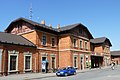
railway station in Frýdek, Czech Republic .JPG) Novější staniční budova KFNB | |||||
| Upload media | |||||
| Instance of | |||||
|---|---|---|---|---|---|
| Part of | |||||
| Location | Frýdek, Frýdek-Místek, Frýdek-Místek District, Moravian-Silesian Region, Czechia | ||||
| Transport network | |||||
| Has part(s) | |||||
| Heritage designation | |||||
| Date of official opening |
| ||||
| Elevation above sea level |
| ||||
| Connecting line | |||||
| Adjacent station | |||||
 | |||||
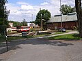
Media in category "Frýdek-Místek (train station)"
The following 17 files are in this category, out of 17 total.
-
 14.05.13 Frýdek-Místek 754.021 (8890676999).jpg 6,016 × 4,000; 17.84 MB
-
 Frýdek, nádraží 1.jpg 3,072 × 2,304; 1.08 MB
-
 Frýdek, nádraží 2.jpg 3,072 × 2,304; 1.09 MB
-
 Frýdek, nádraží, depo.jpg 3,072 × 2,304; 1.48 MB
-
 Frýdek, nádraží, interiér.jpg 3,072 × 2,304; 1.16 MB
-
 Frýdek, nádraží, nástupiště.jpg 3,072 × 2,304; 991 KB
-
 Frýdek, nádraží, pohlednice 1919, 01a.jpg 814 × 526; 126 KB
-
 Frýdek-Místek nádraží.jpg 960 × 720; 108 KB
-
 Frýdek-Místek, vlakové nádraží (1).JPG 4,000 × 3,000; 6.89 MB
-
 Frýdek-Místek, vlakové nádraží (2).JPG 3,442 × 2,559; 3.34 MB
-
 Frýdek-Místek, vlakové nádraží (3).JPG 3,883 × 2,800; 4.55 MB
-
 Frýdek-Místek, vlakové nádraží (4).JPG 2,867 × 3,898; 4.59 MB
-
 Frýdek-Místek, vlakové nádraží (5).JPG 3,906 × 2,612; 4.29 MB
-
 Frýdek-Místek, vlakové nádraží (6).JPG 4,000 × 3,000; 5.79 MB
-
 Frýdek-Místek, vlakové nádraží (7).JPG 4,000 × 3,000; 6.21 MB
-
 Frýdek-Místek, vlakové nádraží, 2012 (1).JPG 4,000 × 3,000; 6.02 MB
-
 Frýdek-Místek, vlakové nádraží, 2012.JPG 3,855 × 2,622; 5.1 MB
.jpg)


.JPG)
.JPG)
.JPG)
.JPG)
.JPG)
.JPG)
.JPG)
