Category:Fröttmaninger Heide
Jump to navigation
Jump to search
| Object location | | View all coordinates using: OpenStreetMap |
|---|
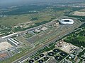
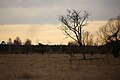
Deutsch: Landschaftsbereich Fröttmaninger Heide in München und im Landkreis München, Oberbayern. Teil des FFH-Gebietes Heideflächen und Lohwälder nördlich von München (7735-371).

| NO WIKIDATA ID FOUND! Search for Fröttmaninger Heide on Wikidata | |
| Upload media |
Subcategories
This category has the following 2 subcategories, out of 2 total.
N
Media in category "Fröttmaninger Heide"
The following 18 files are in this category, out of 18 total.
-
 050727057-LA.JPG 4,048 × 3,040; 2.4 MB
-
 2011-10-16 Lycoperdon pratense.jpg 2,000 × 1,500; 1.08 MB
-
 2014-02-13 Fröttmaninger Heide 5659.jpg 3,599 × 5,399; 2.32 MB
-
 2014-02-13 Fröttmaninger Heide 5666.jpg 5,472 × 3,648; 1.76 MB
-
 2014-02-13 Fröttmaninger Heide 5679.jpg 5,311 × 3,541; 1.43 MB
-
 2014-02-13 Fröttmaninger Heide 5734.jpg 5,472 × 3,648; 7.87 MB
-
 2014-02-13 Fröttmaninger Heide 5748.jpg 5,472 × 3,648; 5.06 MB
-
 2014-02-13 Fröttmaninger Heide 5749.jpg 5,223 × 3,483; 4.45 MB
-
 Aerial image of Südliche Fröttmaninger Heide (view from the south).jpg 4,000 × 2,400; 5.22 MB
-
 Fröttmaninger Heide1.jpg 2,400 × 1,600; 2.99 MB
-
 Fröttmaninger Heide2.jpg 2,400 × 1,600; 2.64 MB
-
 Fröttmaninger Heide3.jpg 2,400 × 1,600; 2.48 MB
-
 Fröttmaninger Heide4.jpg 2,400 × 1,600; 2.3 MB
-
 Fröttmaninger Heide5.jpg 1,600 × 2,400; 1.56 MB
-
 Fröttmaninger Heide6.jpg 2,400 × 1,600; 2.03 MB
-
 Fröttmaninger Heide7.jpg 2,400 × 1,600; 2.57 MB
-
 Fröttmaninger Heide8.jpg 2,400 × 1,600; 2 MB
-
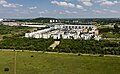 Siedlung Haidpark.jpg 4,526 × 2,785; 3.4 MB


.jpg)


