Category:Fränkisches Tor (Schlosspark Milkel)
Jump to navigation
Jump to search
| Object location | | View all coordinates using: OpenStreetMap |
|---|
This is the category for an architectural monument.
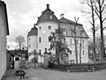
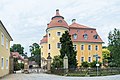
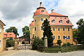
It is on the list of cultural monuments of Milkel (Radibor), no. 09253240.
It is on the list of cultural monuments of Milkel (Radibor), no. 09253240.
Media in category "Fränkisches Tor (Schlosspark Milkel)"
The following 10 files are in this category, out of 10 total.
-
 20080316325DR Milkel (Radibor) Schloß.jpg 2,440 × 1,794; 5.6 MB
-
 20080316331DR Milkel (Radibor) Schloß.jpg 2,437 × 1,847; 2.37 MB
-
 Milkel Schloss-01.jpg 5,472 × 3,648; 2.66 MB
-
 Milkel-Fränkisches-Tor-1.jpg 3,441 × 2,414; 2.21 MB
-
 Milkel-Fränkisches-Tor-2.jpg 3,431 × 2,349; 2.05 MB
-
 Radibor Milkel - Schloß Milkel - Schlosspark - Fränkisches Tor + Schloss 01 ies.jpg 5,616 × 3,744; 10.9 MB
-
 Radibor Milkel - Schloß Milkel - Schlosspark - Fränkisches Tor 01 ies.jpg 5,616 × 3,744; 5.23 MB
-
 Radibor Milkel - Schloß Milkel - Schlosspark - Fränkisches Tor 02 ies.jpg 5,616 × 3,744; 9.79 MB
-
 Radibor Milkel - Schloß Milkel - Schlosspark - Fränkisches Tor 03 ies.jpg 5,616 × 3,744; 6.95 MB
-
 Radibor Milkel - Schloß Milkel - Schlosspark - Fränkisches Tor 04 ies.jpg 5,616 × 3,744; 6.34 MB
_Schlo%C3%9F.jpg)
_Schlo%C3%9F.jpg)


