Category:Foxhole, Cornwall
Jump to navigation
Jump to search
village in parish of St Stephen-in-Brannel, Cornwall  | |||||
| Upload media | |||||
| Instance of | |||||
|---|---|---|---|---|---|
| Location | Cornwall, South West England, England | ||||
 | |||||
English: Foxhole is a village in central Cornwall, in the United Kingdom. It lies within the parish of St Stephen-in-Brannel, and has a primary school.
Media in category "Foxhole, Cornwall"
The following 21 files are in this category, out of 21 total.
-
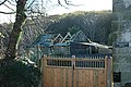
 Chalets in the "Cornish Alps" - geograph.org.uk - 81139.jpg 640 × 406; 101 KB
-
 Farmhouse and Waste Tip - geograph.org.uk - 432223.jpg 640 × 426; 86 KB
-
 Foxhole, Cornwall.jpg 2,960 × 2,136; 894 KB
-
 Mica Dam near Carpalla - geograph.org.uk - 81128.jpg 640 × 440; 97 KB
-
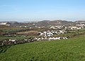
 The View from Foxhole - geograph.org.uk - 83765.jpg 640 × 411; 98 KB
-
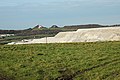 Waste Tips and Pasture - geograph.org.uk - 432176.jpg 640 × 426; 88 KB
-
 Country Lane near Carloggas - geograph.org.uk - 432519.jpg 640 × 426; 130 KB
-
 Croft House - geograph.org.uk - 277143.jpg 640 × 480; 91 KB
-
 Farm at Easter Clunes - geograph.org.uk - 277342.jpg 640 × 480; 161 KB
-
 Field and Trees - geograph.org.uk - 277108.jpg 640 × 480; 117 KB
-
 In Glen Convinth - geograph.org.uk - 265219.jpg 640 × 480; 61 KB
-
 In Glen Convinth - geograph.org.uk - 265220.jpg 640 × 480; 60 KB
-
 Minor road near Foxhole - geograph.org.uk - 658150.jpg 640 × 426; 111 KB
-
 Minor road near Foxhole - geograph.org.uk - 658154.jpg 640 × 426; 133 KB
-
 Moonshine Barn - geograph.org.uk - 432338.jpg 640 × 426; 110 KB
-
 Pasture Land - geograph.org.uk - 277117.jpg 640 × 480; 69 KB
-
 Pine Wood - geograph.org.uk - 277132.jpg 640 × 480; 112 KB
-
 Roadside House at Goonamarris - geograph.org.uk - 432323.jpg 640 × 426; 84 KB
-
 Ruined Croft House and Building - geograph.org.uk - 277127.jpg 640 × 480; 97 KB
-
 Stream near Gonnamarris - geograph.org.uk - 432492.jpg 640 × 426; 139 KB
-
 The Valley at Foxhole - geograph.org.uk - 432150.jpg 640 × 426; 124 KB


