Category:Fort Saint-Sébastien
Jump to navigation
Jump to search
| Object location | | View all coordinates using: OpenStreetMap |
|---|
 | |||||
| Upload media | |||||
| Instance of | |||||
|---|---|---|---|---|---|
| Location |
| ||||
| Different from | |||||
 | |||||
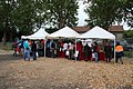
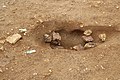
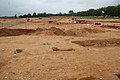
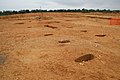
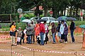
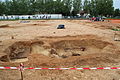
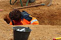
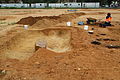
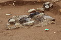
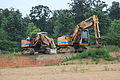
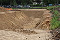
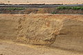
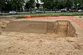
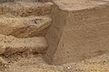
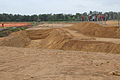
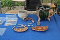
Français : Le fort Saint-Sébastien était un fort destiné à l'entrainement des armées de Louis XIV à la poliorcétique (la défense et la prise de places fortes). Il ne fut utilisé que deux ans (1669 et 1670) puis rasé.
Il est situé dans une boucle de la Seine, au nord de l'actuel département des Yvelines, au nord-ouest de Paris
Il est situé dans une boucle de la Seine, au nord de l'actuel département des Yvelines, au nord-ouest de Paris
English: The Fort St. Sebastien was a fort for the training of the armies of Louis XIV for siege warfare (defending and taking strongholds). It was used for two years (1669 and 1670) and then leveled.
It was located near the Seine river, in north of the current département of Yvelines, in north-west of Paris.
It was located near the Seine river, in north of the current département of Yvelines, in north-west of Paris.
Media in category "Fort Saint-Sébastien"
The following 96 files are in this category, out of 96 total.
-
 Fort Saint-Sébastien - Visite des fouilles juin 2012 01.jpg 5,184 × 3,456; 8.21 MB
-
 Fort Saint-Sébastien - Visite des fouilles juin 2012 02.jpg 5,184 × 3,456; 9.37 MB
-
 Fort Saint-Sébastien - Visite des fouilles juin 2012 03.jpg 5,184 × 3,456; 6.67 MB
-
 Fort Saint-Sébastien - Visite des fouilles juin 2012 04.jpg 5,184 × 3,456; 9.06 MB
-
 Fort Saint-Sébastien - Visite des fouilles juin 2012 05.jpg 5,184 × 3,456; 10.62 MB
-
 Fort Saint-Sébastien - Visite des fouilles juin 2012 06.jpg 5,184 × 3,456; 9.35 MB
-
 Fort Saint-Sébastien - Visite des fouilles juin 2012 07.jpg 5,184 × 3,456; 6.82 MB
-
 Fort Saint-Sébastien - Visite des fouilles juin 2012 08.jpg 5,184 × 3,456; 7.03 MB
-
 Fort Saint-Sébastien - Visite des fouilles juin 2012 09.jpg 5,184 × 3,456; 9 MB
-
 Fort Saint-Sébastien - Visite des fouilles juin 2012 10.jpg 5,184 × 3,456; 10.18 MB
-
 Fort Saint-Sébastien - Visite des fouilles juin 2012 11.jpg 5,184 × 3,456; 10.66 MB
-
 Fort Saint-Sébastien - Visite des fouilles juin 2012 12.jpg 5,184 × 3,456; 10.13 MB
-
 Fort Saint-Sébastien - Visite des fouilles juin 2012 13.jpg 5,184 × 3,456; 11.17 MB
-
 Fort Saint-Sébastien - Visite des fouilles juin 2012 14.jpg 5,184 × 3,456; 8.84 MB
-
 Fort Saint-Sébastien - Visite des fouilles juin 2012 15.jpg 5,184 × 3,456; 9.5 MB
-
 Fort Saint-Sébastien - Visite des fouilles juin 2012 16.jpg 5,184 × 3,456; 11.52 MB
-
 Fort Saint-Sébastien - Visite des fouilles juin 2012 17.jpg 5,184 × 3,456; 11.59 MB
-
 Fort Saint-Sébastien - Visite des fouilles juin 2012 18.jpg 5,184 × 3,456; 11.38 MB
-
 Fort Saint-Sébastien - Visite des fouilles juin 2012 19.jpg 5,184 × 3,456; 9.73 MB
-
 Fort Saint-Sébastien - Visite des fouilles juin 2012 20.jpg 5,184 × 3,456; 11.59 MB
-
 Fort Saint-Sébastien - Visite des fouilles juin 2012 21.jpg 5,184 × 3,456; 11.52 MB
-
 Fort Saint-Sébastien - Visite des fouilles juin 2012 22.jpg 5,184 × 3,456; 11.04 MB
-
 Fort Saint-Sébastien - Visite des fouilles juin 2012 23.jpg 5,184 × 3,456; 11.7 MB
-
 Fort Saint-Sébastien - Visite des fouilles juin 2012 24.jpg 5,184 × 3,456; 9.73 MB
-
 Fort Saint-Sébastien - Visite des fouilles juin 2012 25.jpg 3,456 × 5,184; 10.95 MB
-
 Fort Saint-Sébastien - Visite des fouilles juin 2012 26.jpg 5,184 × 3,456; 11.01 MB
-
 Fort Saint-Sébastien - Visite des fouilles juin 2012 27.jpg 5,184 × 3,456; 8.1 MB
-
 Fort Saint-Sébastien - Visite des fouilles juin 2012 28.jpg 5,184 × 3,456; 10.46 MB
-
 Fort Saint-Sébastien - Visite des fouilles juin 2012 29.jpg 5,184 × 3,456; 10.56 MB
-
 Fort Saint-Sébastien - Visite des fouilles juin 2012 30.jpg 5,184 × 3,456; 11.29 MB
-
 Fort Saint-Sébastien - Visite des fouilles juin 2012 31.jpg 5,184 × 3,456; 10.85 MB
-
 Fort Saint-Sébastien - Visite des fouilles juin 2012 32.jpg 5,184 × 3,456; 11.06 MB
-
 Fort Saint-Sébastien - Visite des fouilles juin 2012 33.jpg 5,184 × 3,456; 10.83 MB
-
 Fort Saint-Sébastien - Visite des fouilles juin 2012 34.jpg 5,184 × 3,456; 11.1 MB
-
 Fort Saint-Sébastien - Visite des fouilles juin 2012 35.jpg 5,184 × 3,456; 7.5 MB
-
 Fort Saint-Sébastien - Visite des fouilles juin 2012 36.jpg 5,184 × 3,456; 6.37 MB
-
 Fort Saint-Sébastien - Visite des fouilles juin 2012 37.jpg 5,184 × 3,456; 9.42 MB
-
 Fort Saint-Sébastien - Visite des fouilles juin 2012 38.jpg 5,184 × 3,456; 10.7 MB
-
 Fort Saint-Sébastien - Visite des fouilles juin 2012 39.jpg 5,184 × 3,456; 6.72 MB
-
 Fort Saint-Sébastien - Visite des fouilles juin 2012 40.jpg 5,184 × 3,456; 9.71 MB
-
 Fort Saint-Sébastien - Visite des fouilles juin 2012 41.jpg 5,184 × 3,456; 10.43 MB
-
 Fort Saint-Sébastien - Visite des fouilles juin 2012 42.jpg 5,184 × 3,456; 8.53 MB
-
 Fort Saint-Sébastien - Visite des fouilles juin 2012 43.jpg 5,184 × 3,456; 10.68 MB
-
 Fort Saint-Sébastien - Visite des fouilles juin 2012 44.jpg 5,184 × 3,456; 8.75 MB
-
 Fort Saint-Sébastien - Visite des fouilles juin 2012 45.jpg 5,184 × 3,456; 7.64 MB
-
 Fort Saint-Sébastien - Visite des fouilles juin 2012 46.jpg 5,184 × 3,456; 8.37 MB
-
 Fort Saint-Sébastien - Visite des fouilles juin 2012 47.jpg 5,184 × 3,456; 9.28 MB
-
 Fort Saint-Sébastien - Visite des fouilles juin 2012 48.jpg 5,184 × 3,456; 10.69 MB
-
 Fort Saint-Sébastien - Visite des fouilles juin 2012 49.jpg 5,184 × 3,456; 9.9 MB
-
 Fort Saint-Sébastien - Visite des fouilles juin 2012 50.jpg 5,184 × 3,456; 9.87 MB
-
 Fort Saint-Sébastien - Visite des fouilles juin 2012 51.jpg 5,184 × 3,456; 8.04 MB
-
 Fort Saint-Sébastien - Visite des fouilles juin 2012 52.jpg 5,184 × 3,456; 9.78 MB
-
 Fort Saint-Sébastien - Visite des fouilles juin 2012 53.jpg 5,184 × 3,456; 9.53 MB
-
 Fort Saint-Sébastien - Visite des fouilles juin 2012 54.jpg 5,184 × 3,456; 8.31 MB
-
 Fort Saint-Sébastien - Visite des fouilles juin 2012 55.jpg 5,184 × 3,456; 9.56 MB
-
 Fort Saint-Sébastien - Visite des fouilles juin 2012 56.jpg 5,184 × 3,456; 7.93 MB
-
 Fort Saint-Sébastien - Visite des fouilles juin 2012 57.jpg 5,184 × 3,456; 10.88 MB
-
 Fort Saint-Sébastien - Visite des fouilles juin 2012 58.jpg 5,184 × 3,456; 9.11 MB
-
 Fort Saint-Sébastien - Visite des fouilles juin 2012 59.jpg 5,184 × 3,456; 9.73 MB
-
 Fort Saint-Sébastien - Visite des fouilles juin 2012 60.jpg 5,184 × 3,456; 10.35 MB
-
 Fort Saint-Sébastien - Visite des fouilles juin 2012 61.jpg 5,184 × 3,456; 10.62 MB
-
 Fort Saint-Sébastien - Visite des fouilles juin 2012 62.jpg 5,184 × 3,456; 9.44 MB
-
 Fort Saint-Sébastien - Visite des fouilles juin 2012 63.jpg 5,184 × 3,456; 8.87 MB
-
 Fort Saint-Sébastien - Visite des fouilles juin 2012 64.jpg 5,184 × 3,456; 9.94 MB
-
 Fort Saint-Sébastien - Visite des fouilles juin 2012 65.jpg 5,184 × 3,456; 10.6 MB
-
 Fort Saint-Sébastien - Visite des fouilles juin 2012 66.jpg 5,184 × 3,456; 8.69 MB
-
 Fort Saint-Sébastien - Visite des fouilles juin 2012 67.jpg 5,184 × 3,456; 10.19 MB
-
 Fort Saint-Sébastien - Visite des fouilles juin 2012 68.jpg 5,184 × 3,456; 10.93 MB
-
 Fort Saint-Sébastien - Visite des fouilles juin 2012 69.jpg 5,184 × 3,456; 11.24 MB
-
 Fort Saint-Sébastien - Visite des fouilles juin 2012 70.jpg 5,184 × 3,456; 10.4 MB
-
 Fort Saint-Sébastien - Visite des fouilles juin 2012 71.jpg 5,184 × 3,456; 10.53 MB
-
 Fort Saint-Sébastien - Visite des fouilles juin 2012 72.jpg 5,184 × 3,456; 10.49 MB
-
 Fort Saint-Sébastien - Visite des fouilles juin 2012 73.jpg 5,184 × 3,456; 10.96 MB
-
 Fort Saint-Sébastien - Visite des fouilles juin 2012 74.jpg 5,184 × 3,456; 10.81 MB
-
 Fort Saint-Sébastien - Visite des fouilles juin 2012 75.jpg 5,184 × 3,456; 9.87 MB
-
 Fort Saint-Sébastien - Visite des fouilles juin 2012 76.jpg 3,456 × 5,184; 9.24 MB
-
 Fort Saint-Sébastien - Visite des fouilles juin 2012 77.jpg 5,184 × 3,456; 10.58 MB
-
 Fort Saint-Sébastien - Visite des fouilles juin 2012 78.jpg 5,184 × 3,456; 10.24 MB
-
 Fort Saint-Sébastien - Visite des fouilles juin 2012 79.jpg 5,184 × 3,456; 12.16 MB
-
 Fort Saint-Sébastien - Visite des fouilles juin 2012 80.jpg 5,184 × 3,456; 8.99 MB
-
 Fort Saint-Sébastien - Visite des fouilles juin 2012 81.jpg 5,184 × 3,456; 7.83 MB
-
 Fort Saint-Sébastien - Visite des fouilles juin 2012 82.jpg 5,184 × 3,456; 8.26 MB
-
 Fort Saint-Sébastien - Visite des fouilles juin 2012 83.jpg 5,184 × 3,456; 9.1 MB
-
 Fort Saint-Sébastien - Visite des fouilles juin 2012 84.jpg 5,184 × 3,456; 9.46 MB
-
 Fort Saint-Sébastien - Visite des fouilles juin 2012 85.jpg 5,184 × 3,456; 7.13 MB
-
 Fort Saint-Sébastien - Visite des fouilles juin 2012 86.jpg 5,184 × 3,456; 7.34 MB
-
 Fort Saint-Sébastien - Visite des fouilles juin 2012 87.jpg 5,184 × 3,456; 6.62 MB
-
 Fort Saint-Sébastien - Visite des fouilles juin 2012 88.jpg 5,184 × 3,456; 6.49 MB
-
 Fort Saint-Sébastien - Visite des fouilles juin 2012 89.jpg 5,184 × 3,456; 6.41 MB
-
 Fort Saint-Sébastien - Visite des fouilles juin 2012 90.jpg 5,184 × 3,456; 6.85 MB
-
 Fort Saint-Sébastien - Visite des fouilles juin 2012 91.jpg 5,184 × 3,456; 7.56 MB
-
 Fort Saint-Sébastien - Visite des fouilles juin 2012 92.jpg 5,184 × 3,456; 6.63 MB
-
 Fort Saint-Sébastien - Visite des fouilles juin 2012 93.jpg 5,184 × 3,456; 6.31 MB
-
 Fort Saint-Sébastien - Visite des fouilles juin 2012 94.jpg 5,184 × 3,456; 7.42 MB
-
 Fort St Sebastien Image aérienne après fouilles.jpg 3,840 × 2,880; 5.65 MB
-
 Fort-Saint Sébastien, Saint-Germain-en-Laye.jpg 502 × 395; 71 KB


