Category:Fort Diamant
Jump to navigation
Jump to search
| Object location | | View all coordinates using: OpenStreetMap |
|---|
|
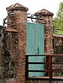
This building is classé au titre des monuments historiques de la France. It is indexed in the base Mérimée, a database of architectural heritage maintained by the French Ministry of Culture, under the reference PA00105909
|
| Object location | | View all coordinates using: OpenStreetMap |
|---|
fort in Remire-Montjoly, French Guyana  | |||||
| Upload media | |||||
| Instance of | |||||
|---|---|---|---|---|---|
| Location | Remire-Montjoly, Canton of Rémire-Montjoly | ||||
| Heritage designation |
| ||||
 | |||||
Media in category "Fort Diamant"
The following 6 files are in this category, out of 6 total.
-
 Fort Diamant vue aérienne par mon.nini.jpg 4,000 × 3,000; 4.72 MB
-
 Fort Diamant.jpg 4,032 × 3,024; 4.04 MB
-
 FortDiamant-04.jpg 6,003 × 2,426; 3.95 MB
-
 FortDiamant-06.jpg 6,542 × 2,835; 5.25 MB
-
 FortDiamant-13.jpg 4,961 × 3,780; 5.02 MB
-
 FortDiamant-14.jpg 3,780 × 4,961; 3.97 MB


