Category:Former vicarage, Ashville Road, Birkenhead
Jump to navigation
Jump to search
| Object location | | View all coordinates using: OpenStreetMap |
|---|
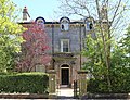
This is a category about listed building number 1292325. |
clergy house in Wirral, Merseyside, England, UK  | |||||
| Upload media | |||||
| Instance of | |||||
|---|---|---|---|---|---|
| Location | Wirral, Merseyside, North West England, England | ||||
| Heritage designation |
| ||||
 | |||||
Grade II listed former vicarage of St Anne's church (now renamed to Christ the King, Beckwith Street), c. 1860; coursed and squared stone with Welsh slate roof.
Media in category "Former vicarage, Ashville Road, Birkenhead"
The following 5 files are in this category, out of 5 total.
-
 Former Vicarage, Ashville Road, Birkenhead (1).jpg 4,608 × 3,456; 4.61 MB
-
 Former Vicarage, Ashville Road, Birkenhead (2).jpg 4,608 × 3,456; 4.76 MB
-
 Former vicarage, Ashville Road, Birkenhead 2019-1.jpg 4,551 × 3,441; 10.98 MB
-
 Former vicarage, Ashville Road, Birkenhead 2019-2.jpg 3,588 × 3,132; 8.34 MB
-
 Former vicarage, Ashville Road, Birkenhead 2019-3.jpg 4,485 × 3,426; 14.38 MB
.jpg)
.jpg)

