Category:Forestry maps of Germany
Jump to navigation
Jump to search
Subcategories
This category has the following 2 subcategories, out of 2 total.
G
- Gadnersche Forstkarten (8 F)
K
Media in category "Forestry maps of Germany"
The following 18 files are in this category, out of 18 total.
-
 1763 Muckenschupf Parzellen.jpg 1,587 × 1,880; 1.7 MB
-
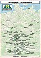 Beschäftigungsort-aktualisert-032020.jpg 3,507 × 4,960; 3.6 MB
-
 Imburg-Horn.jpg 1,038 × 622; 147 KB
-
 Karte der Oberförsterei Waldau im Regierungsbezirk Kassel.tif 3,437 × 3,361; 33.34 MB
-
 Karte der Oberwaldungen des Oberamts Umstadt.jpg 5,140 × 3,704; 22.77 MB
-
 Karte des Amorbacher, Schaafheimer, Umstädter und Richener Waldes.jpg 4,982 × 3,771; 20.26 MB
-
 Karte des Forstreviers Elgershausen.tif 4,006 × 2,878; 33.27 MB
-

-
 Karte eines Waldstücks bei Klein-Zimmern.jpg 4,961 × 3,955; 27.47 MB
-
 Pulvermühle Gröningen auf Forstkarte 1682.jpg 1,069 × 833; 367 KB
-
 Rotenacker 1590 auf Forstkarte von Gadner.jpg 605 × 629; 361 KB
-
 Wegenetzkarte des Forstes Oberrosphe.tif 3,475 × 3,484; 34.66 MB
-
 Wirtschaftskarte der Oberförsterei Grebenstein.tif 2,299 × 2,668; 17.57 MB
-
 Wirtschaftskarte von der königlichen Oberförsterei Ehlen.jpg 2,735 × 3,000; 1.14 MB
-
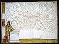
 Physikalisch-statistischer Atlas des Deutschen Reichs 1878 (131438615).jpg 12,041 × 9,496; 46.77 MB
-
 Physikalisch-statistischer Atlas des Deutschen Reichs 1878 (131438636).jpg 9,391 × 5,896; 19.78 MB
-
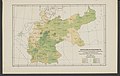 Physikalisch-statistischer Atlas des Deutschen Reichs 1878 (131438641).jpg 9,391 × 5,984; 19.82 MB
-


.jpg)
.jpg)
.jpg)