Category:Footbridge south of Mill Lane viaduct, Newton-le-Willows
Jump to navigation
Jump to search
| Object location | | View all coordinates using: OpenStreetMap |
|---|
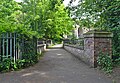
This bridge carries the footpath from the viaduct to Park Road South over the Newton Brook.
Media in category "Footbridge south of Mill Lane viaduct, Newton-le-Willows"
The following 4 files are in this category, out of 4 total.
-
 Footbridge south of Mill Lane viaduct, Newton-le-Willows 1.jpg 5,181 × 3,437; 25.6 MB
-
 Footbridge south of Mill Lane viaduct, Newton-le-Willows 2.jpg 5,013 × 3,338; 23.62 MB
-
 Footbridge south of Mill Lane viaduct, Newton-le-Willows 3.jpg 4,358 × 2,941; 21.67 MB
-
 Footbridge south of Mill Lane viaduct, Newton-le-Willows 4.jpg 4,608 × 3,195; 24.68 MB


