Category:Footbridge at Queens Graving Dock
Jump to navigation
Jump to search
| Object location | | View all coordinates using: OpenStreetMap |
|---|
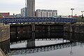
Footbridge adjacent to the gates between Queens Dock and Queens Graving Dock. Not shown on old maps, so it appears to have been added in 1993 when the HMCE offices were built.
Media in category "Footbridge at Queens Graving Dock"
The following 2 files are in this category, out of 2 total.
-
 Footbridge at Queens Graving Dock 1.jpg 5,184 × 3,456; 9.63 MB
-
 Footbridge at Queens Graving Dock 2.jpg 5,184 × 3,456; 8.21 MB

