Category:Footbridge at Bromborough Rake railway station
Jump to navigation
Jump to search
| Object location | | View all coordinates using: OpenStreetMap |
|---|
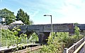
This bridge to the platforms also carries a public footpath from Bromborough to Poulton Hall across the Wirral Line of Merseyrail. It is designated CRR2/37 and is 10.43 miles from the datum at Chester.
Media in category "Footbridge at Bromborough Rake railway station"
The following 7 files are in this category, out of 7 total.
-
 Footbridge at Bromborough Rake railway station 1.jpg 4,817 × 3,067; 19.57 MB
-
 Footbridge at Bromborough Rake railway station 2.jpg 5,004 × 3,153; 18.5 MB
-
 Footbridge at Bromborough Rake railway station 3.jpg 5,074 × 3,326; 21.37 MB
-
 Footbridge at Bromborough Rake railway station 4.jpg 3,462 × 5,198; 20.93 MB
-
 Footbridge, Bromborough Rake Railway Station (geograph 2986470).jpg 1,024 × 683; 188 KB
-
 Footpath from Bromborough Rake to Poulton Hall 1.jpg 3,387 × 4,620; 19.44 MB
-
 Footpath from Bromborough Rake to Poulton Hall 2.jpg 3,253 × 4,700; 18.41 MB


.jpg)

