Category:Footbridge at Bootle Oriel Road railway station
Jump to navigation
Jump to search
| Object location | | View all coordinates using: OpenStreetMap |
|---|
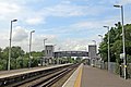
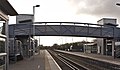
Footbridge with lift access for wheelchairs on either side of the tracks. Designated HXS3/10A, it is 2.76 miles from the datum at the former Liverpool Exchange Station.
Media in category "Footbridge at Bootle Oriel Road railway station"
The following 8 files are in this category, out of 8 total.
-
 Footbridge, Bootle Oriel Road Railway Station (geograph 2995625).jpg 1,024 × 683; 98 KB
-
 Oriel Road footbridge 1.jpg 4,940 × 3,389; 21.04 MB
-
 Oriel Road footbridge 2.jpg 4,613 × 3,306; 14.03 MB
-
 Oriel Road footbridge 3.jpg 5,108 × 3,428; 17.08 MB
-
 Oriel Road footbridge 4.jpg 5,030 × 3,240; 19.47 MB
-
 Oriel Road footbridge 5.jpg 5,053 × 3,355; 23.18 MB
-
 Oriel Road footbridge 6.jpg 4,774 × 2,788; 12.71 MB
-
 Oriel Road footbridge plate.jpg 3,384 × 2,786; 9.7 MB
.jpg)


