Category:Fontaine de l'Homme sauvage (Ammerschwihr)
Jump to navigation
Jump to search
| Object location | | View all coordinates using: OpenStreetMap |
|---|
|
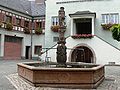
This building is classé au titre des monuments historiques de la France. It is indexed in the base Mérimée, a database of architectural heritage maintained by the French Ministry of Culture, under the reference PA00085327
|
This object is classé Monument Historique in the base Palissy, database of the French furniture patrimony of the French ministry of culture, under the reference IM68007094.
|
 | |||||
| Upload media | |||||
| Instance of | |||||
|---|---|---|---|---|---|
| Location | Ammerschwihr, canton of Kaysersberg | ||||
| Street address |
| ||||
| Heritage designation |
| ||||
 | |||||
Media in category "Fontaine de l'Homme sauvage (Ammerschwihr)"
The following 5 files are in this category, out of 5 total.
-
 Ammerschwihr 020.JPG 3,072 × 2,304; 3.06 MB
-
 Ammerschwihr-Fontaine de l'Homme sauvage (1).jpg 3,648 × 2,736; 2.87 MB
-
 Ammerschwihr-Fontaine de l'Homme sauvage (2).jpg 2,736 × 3,648; 3.21 MB
-
 Colonne de la fontaine de l'homme sauvage.jpg 2,902 × 3,928; 1.74 MB
-
 Fontaine de l'homme sauvage.jpg 4,000 × 3,000; 1.99 MB
.jpg)
.jpg)


Categories:
- Monuments historiques in Ammerschwihr
- Objets monuments historiques in Ammerschwihr
- Fountains in Ammerschwihr
- Monuments historiques in Haut-Rhin (fountains)
- 16th-century fountains in Haut-Rhin
- Fountains built in 1560
- Built in Haut-Rhin in 1560
- Sandstone statues in Arrondissement Colmar-Ribeauvillé
- Fountain statues in Haut-Rhin
- Renaissance statues in Haut-Rhin
- Statues of standing men in Alsace
- Renaissance fountains in Haut-Rhin