Category:Fontaine de Lessoc
Jump to navigation
Jump to search
| Object location | | View all coordinates using: OpenStreetMap |
|---|
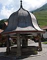
fountain in Lessoc in the canton of Fribourg, Switzerland  | |||||
| Upload media | |||||
| Instance of | |||||
|---|---|---|---|---|---|
| Part of | |||||
| Made from material |
| ||||
| Location | Lessoc, Haut-Intyamon, Gruyère District, Canton of Fribourg, Switzerland | ||||
| Street address |
| ||||
| Heritage designation | |||||
| Inception |
| ||||
 | |||||
Media in category "Fontaine de Lessoc"
The following 3 files are in this category, out of 3 total.
-
 Lessoc-fontaine-HF.jpg 1,333 × 2,047; 2.21 MB
-
 Lessoc-fontaine.jpg 2,000 × 1,333; 2.22 MB
-
 Lessoc02.JPG 1,172 × 1,496; 571 KB

