Category:Font de Sampitot
Jump to navigation
Jump to search
| Object location | | View all coordinates using: OpenStreetMap |
|---|
 | |||||
| Upload media | |||||
| Instance of | |||||
|---|---|---|---|---|---|
| Genre | |||||
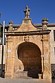
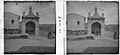
| Location | Os de Balaguer, Noguera, Ponent, Province of Lleida, Catalonia | ||||
| Street address |
| ||||
| Architectural style | |||||
| Heritage designation |
| ||||
| Inception |
| ||||
| Elevation above sea level |
| ||||
 | |||||
Català: Font de Sampitot (Os de Balaguer)
This is a category about a building listed in the Catalan heritage register as Bé Cultural d'Interès Local (BCIL) under the reference IPA-22284. |
Media in category "Font de Sampitot"
The following 6 files are in this category, out of 6 total.
-
 FONT DE SAMPITOT - OS DE BALAGUER - IB-038.jpg 2,048 × 1,536; 932 KB
-
 FONT DE SAMPITOT - OS DE BALAGUER - IB-039.jpg 2,048 × 1,536; 936 KB
-
 FONT DE SAMPITOT - OS DE BALAGUER - IB-040.jpg 2,048 × 1,536; 962 KB
-
 Font de Sampitot, Os de Balaguer.jpg 3,072 × 4,608; 5.23 MB
-
 Font de Sampitot.jpg 4,000 × 6,000; 10.02 MB
-
 Font de Sant Pitot.jpeg 1,574 × 720; 149 KB


