Category:Fonda l'Estrella, Palafrugell
Jump to navigation
Jump to search
| Object location | | View all coordinates using: OpenStreetMap |
|---|
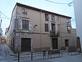
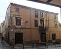
building in Girona Province, Spain  | |||||
| Upload media | |||||
| Instance of | |||||
|---|---|---|---|---|---|
| Location | Palafrugell, Baix Empordà, Province of Girona, Catalonia | ||||
| Heritage designation |
| ||||
 | |||||
Català: Fonda l'Estrella, edifici de Palafrugell.
This is a category about a building listed in the Catalan heritage register as Bé Cultural d'Interès Local (BCIL) under the reference IPA-4228. |
Media in category "Fonda l'Estrella, Palafrugell"
The following 39 files are in this category, out of 39 total.
-
 CasaEstrella2.JPG 4,000 × 3,000; 4.79 MB
-
 CasaEstrella3.JPG 3,000 × 4,000; 4.84 MB
-
 CasaEstrella4.JPG 4,000 × 3,000; 4.7 MB
-
 CasaEstrella5.JPG 4,000 × 3,000; 4.78 MB
-
 Fonda 6.JPG 3,264 × 2,448; 2.4 MB
-
 Fonda Estrella 100.jpg 3,072 × 4,608; 2.17 MB
-
 Fonda Estrella 101.jpg 2,872 × 4,309; 1.92 MB
-
 Fonda Estrella 102.jpg 3,072 × 4,608; 2.24 MB
-
 Fonda Estrella 103.jpg 3,072 × 4,608; 2.03 MB
-
 Fonda estrella 2.JPG 2,048 × 1,536; 699 KB
-
 Fonda estrella 3.JPG 1,536 × 2,048; 698 KB
-
 Fonda Estrella detall finestra angelets.jpg 4,000 × 3,000; 2.66 MB
-
 Fonda Estrella façana caritat.jpg 4,000 × 3,000; 1.7 MB
-
 Fonda Estrella FiV gent.jpg 3,008 × 2,000; 2.44 MB
-
 Fonda Estrella FiV.jpg 3,008 × 2,000; 2.89 MB
-
 Fonda estrella.JPG 2,048 × 1,536; 685 KB
-
 Fonda L'Estrella (01).JPG 1,920 × 2,560; 1.02 MB
-
 Fonda L'Estrella (02).JPG 2,560 × 1,920; 945 KB
-
 Fonda L'Estrella (03).JPG 1,920 × 2,560; 1.09 MB
-
 Fonda L'Estrella (04).JPG 1,920 × 2,560; 1.09 MB
-
 Fonda l'Estrella 01.JPG 4,000 × 3,000; 2.9 MB
-
 Fonda l'Estrella 02.JPG 3,000 × 4,000; 2.35 MB
-
 Fonda l'Estrella 03.JPG 4,000 × 3,000; 2.64 MB
-
 Fonda l'Estrella 04.JPG 4,000 × 3,000; 2.82 MB
-
 Fonda l'Estrella 05.JPG 4,000 × 3,000; 2.66 MB
-
 Fonda l'Estrella 06.JPG 3,000 × 4,000; 2.13 MB
-
 Fonda l'Estrella 07.JPG 4,000 × 3,000; 2.66 MB
-
 FondaEstrella Palafrugell a.JPG 2,646 × 2,115; 1.04 MB
-
 FondaEstrella Palafrugell b.JPG 3,616 × 2,712; 1.88 MB
-
 FondaEstrella Palafrugell c.JPG 2,603 × 3,545; 2.11 MB
-
 FondaEstrella Palafrugell d.JPG 3,616 × 2,712; 1.84 MB
-
 FondaEstrella Palafrugell e.JPG 3,616 × 2,712; 2.73 MB
-
 FondaEstrella Palafrugell f.JPG 3,616 × 2,712; 2.12 MB
-
 FondaEstrella Palafrugell g.JPG 3,616 × 2,712; 2.31 MB
-
 FondaEstrella Palafrugell h.JPG 3,376 × 2,664; 1.76 MB
-
 FondaEstrella Palafrugell i.JPG 3,616 × 2,712; 2.6 MB
-
 Vikipedia 8-9-2012 049.JPG 3,264 × 2,448; 2.86 MB
-
 Vikipedia 8-9-2012 050.JPG 3,264 × 2,448; 2.45 MB
-
 Vikipedia 8-9-2012 056.JPG 3,264 × 2,448; 2.71 MB


.JPG)
.JPG)
.JPG)
.JPG)


