Category:Flood protection on the Humber Estuary
Jump to navigation
Jump to search
Media in category "Flood protection on the Humber Estuary"
The following 18 files are in this category, out of 18 total.
-
 'Oss Wash', Kingston upon Hull, Jun 23.jpg 4,176 × 2,784; 3.54 MB
-
 East Level Bank - geograph.org.uk - 617435.jpg 640 × 427; 70 KB
-
 Flood Barrier - geograph.org.uk - 361344.jpg 640 × 480; 99 KB
-
 Floodgates at Corporation Pier, Kingston upon Hull, Jun23.jpg 4,176 × 2,784; 3.46 MB
-
 Humber Bank - geograph.org.uk - 541528.jpg 640 × 480; 111 KB
-
 Humber Bank - geograph.org.uk - 500728.jpg 556 × 640; 162 KB
-
 Humber Flood Defence Bank - geograph.org.uk - 165063.jpg 640 × 426; 93 KB
-
 Humber Flood Prevention Bank - geograph.org.uk - 500641.jpg 640 × 426; 150 KB
-
 Humber Flood Prevention Bank - geograph.org.uk - 500715.jpg 640 × 460; 122 KB
-
 Main Street, Paull Village - geograph.org.uk - 651348.jpg 640 × 480; 62 KB
-
 New Flood Defences - geograph.org.uk - 293011.jpg 640 × 300; 68 KB
-

-
 Raising the Flood Defences - geograph.org.uk - 72827.jpg 640 × 480; 114 KB
-
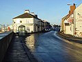
 Sea defences along the Humber - geograph.org.uk - 649357.jpg 640 × 427; 45 KB
-
 Where the Hedon Haven meets the Humber - geograph.org.uk - 557091.jpg 640 × 480; 110 KB
-
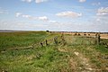
 Flood bank west of Whitton - geograph.org.uk - 801521.jpg 640 × 480; 93 KB
-
 The Devil's Causeway near Whitton - geograph.org.uk - 931965.jpg 640 × 425; 81 KB
-
 Whitton Ness - geograph.org.uk - 106749.jpg 640 × 426; 145 KB


