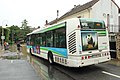
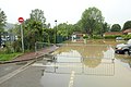
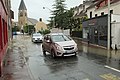
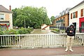
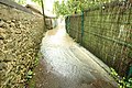
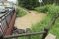
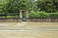
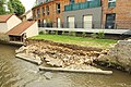
Category:Flood of May 31, 2016 at Saint-Rémy-lès-Chevreuse
Jump to navigation
Jump to search
Français : Inondation du 31 mai 2016 à Saint-Rémy-lès-Chevreuse
| Object location | | View all coordinates using: OpenStreetMap |
|---|
Media in category "Flood of May 31, 2016 at Saint-Rémy-lès-Chevreuse"
The following 59 files are in this category, out of 59 total.
-
 Inondation du 31 mai 2016 à Saint-Rémy-lès-Chevreuse - 01.jpg 5,184 × 3,456; 5.94 MB
-
 Inondation du 31 mai 2016 à Saint-Rémy-lès-Chevreuse - 02.jpg 5,184 × 3,456; 6.31 MB
-
 Inondation du 31 mai 2016 à Saint-Rémy-lès-Chevreuse - 03.jpg 5,184 × 3,456; 6.6 MB
-
 Inondation du 31 mai 2016 à Saint-Rémy-lès-Chevreuse - 04.jpg 5,184 × 3,456; 6.4 MB
-
 Inondation du 31 mai 2016 à Saint-Rémy-lès-Chevreuse - 05.jpg 5,184 × 3,456; 6.17 MB
-
 Inondation du 31 mai 2016 à Saint-Rémy-lès-Chevreuse - 06.jpg 5,184 × 3,456; 6.07 MB
-
 Inondation du 31 mai 2016 à Saint-Rémy-lès-Chevreuse - 07.jpg 5,184 × 3,456; 5.91 MB
-
 Inondation du 31 mai 2016 à Saint-Rémy-lès-Chevreuse - 08.jpg 5,184 × 3,456; 6.52 MB
-
 Inondation du 31 mai 2016 à Saint-Rémy-lès-Chevreuse - 09.jpg 5,184 × 3,456; 6.45 MB
-
 Inondation du 31 mai 2016 à Saint-Rémy-lès-Chevreuse - 10.jpg 5,184 × 3,456; 6.59 MB
-
 Inondation du 31 mai 2016 à Saint-Rémy-lès-Chevreuse - 11.jpg 5,184 × 3,456; 6.24 MB
-
 Inondation du 31 mai 2016 à Saint-Rémy-lès-Chevreuse - 12.jpg 5,184 × 3,456; 4.91 MB
-
 Inondation du 31 mai 2016 à Saint-Rémy-lès-Chevreuse - 13.jpg 5,184 × 3,456; 6.34 MB
-
 Inondation du 31 mai 2016 à Saint-Rémy-lès-Chevreuse - 14.jpg 5,184 × 3,456; 5.89 MB
-
 Inondation du 31 mai 2016 à Saint-Rémy-lès-Chevreuse - 15.jpg 5,184 × 3,456; 6.3 MB
-
 Inondation du 31 mai 2016 à Saint-Rémy-lès-Chevreuse - 16.jpg 5,184 × 3,456; 5.58 MB
-
 Inondation du 31 mai 2016 à Saint-Rémy-lès-Chevreuse - 17.jpg 5,184 × 3,456; 6.69 MB
-
 Inondation du 31 mai 2016 à Saint-Rémy-lès-Chevreuse - 18.jpg 5,184 × 3,456; 5.41 MB
-
 Inondation du 31 mai 2016 à Saint-Rémy-lès-Chevreuse - 19.jpg 5,184 × 3,456; 6.55 MB
-
 Inondation du 31 mai 2016 à Saint-Rémy-lès-Chevreuse - 20.jpg 5,184 × 3,456; 6.51 MB
-
 Inondation du 31 mai 2016 à Saint-Rémy-lès-Chevreuse - 21.jpg 5,184 × 3,456; 5.69 MB
-
 Inondation du 31 mai 2016 à Saint-Rémy-lès-Chevreuse - 22.jpg 5,184 × 3,456; 5.17 MB
-
 Inondation du 31 mai 2016 à Saint-Rémy-lès-Chevreuse - 23.jpg 5,184 × 3,456; 6.05 MB
-
 Inondation du 31 mai 2016 à Saint-Rémy-lès-Chevreuse - 24.jpg 5,184 × 3,456; 6.67 MB
-
 Inondation du 31 mai 2016 à Saint-Rémy-lès-Chevreuse - 25.jpg 5,184 × 3,456; 6.96 MB
-
 Inondation du 31 mai 2016 à Saint-Rémy-lès-Chevreuse - 26.jpg 5,184 × 3,456; 7.27 MB
-
 Inondation du 31 mai 2016 à Saint-Rémy-lès-Chevreuse - 27.jpg 5,184 × 3,456; 6.55 MB
-
 Inondation du 31 mai 2016 à Saint-Rémy-lès-Chevreuse - 28.jpg 5,184 × 3,456; 6.61 MB
-
 Inondation du 31 mai 2016 à Saint-Rémy-lès-Chevreuse - 29.jpg 5,184 × 3,456; 6.62 MB
-
 Inondation du 31 mai 2016 à Saint-Rémy-lès-Chevreuse - 30.jpg 5,184 × 3,456; 6.5 MB
-
 Inondation du 31 mai 2016 à Saint-Rémy-lès-Chevreuse - 31.jpg 5,184 × 3,456; 6.41 MB
-
 Inondation du 31 mai 2016 à Saint-Rémy-lès-Chevreuse - 32.jpg 5,184 × 3,456; 7.61 MB
-
 Inondation du 31 mai 2016 à Saint-Rémy-lès-Chevreuse - 33.jpg 5,184 × 3,456; 6.24 MB
-
 Inondation du 31 mai 2016 à Saint-Rémy-lès-Chevreuse - 34.jpg 5,184 × 3,456; 7.63 MB
-
 Inondation du 31 mai 2016 à Saint-Rémy-lès-Chevreuse - 35.jpg 5,184 × 3,456; 7.61 MB
-
 Inondation du 31 mai 2016 à Saint-Rémy-lès-Chevreuse - 36.jpg 5,184 × 3,456; 10.67 MB
-
 Inondation du 31 mai 2016 à Saint-Rémy-lès-Chevreuse - 37.jpg 5,184 × 3,456; 9.87 MB
-
 Inondation du 31 mai 2016 à Saint-Rémy-lès-Chevreuse - 38.jpg 5,184 × 3,456; 7.67 MB
-
 Inondation du 31 mai 2016 à Saint-Rémy-lès-Chevreuse - 39.jpg 5,184 × 3,456; 6.05 MB
-
 Inondation du 31 mai 2016 à Saint-Rémy-lès-Chevreuse - 40.jpg 5,184 × 3,456; 8.61 MB
-
 Inondation du 31 mai 2016 à Saint-Rémy-lès-Chevreuse - 41.jpg 5,184 × 3,456; 8.22 MB
-
 Inondation du 31 mai 2016 à Saint-Rémy-lès-Chevreuse - 42.jpg 5,184 × 3,456; 9.47 MB
-
 Inondation du 31 mai 2016 à Saint-Rémy-lès-Chevreuse - 43.jpg 5,184 × 3,456; 6.81 MB
-
 Inondation du 31 mai 2016 à Saint-Rémy-lès-Chevreuse - 44.jpg 5,184 × 3,456; 7.06 MB
-
 Inondation du 31 mai 2016 à Saint-Rémy-lès-Chevreuse - 45.jpg 5,184 × 3,456; 7.31 MB
-
 Inondation du 31 mai 2016 à Saint-Rémy-lès-Chevreuse - 46.jpg 5,184 × 3,456; 7.4 MB
-
 Inondation du 31 mai 2016 à Saint-Rémy-lès-Chevreuse - 47.jpg 5,184 × 3,456; 6.62 MB
-
 Inondation du 31 mai 2016 à Saint-Rémy-lès-Chevreuse - 48.jpg 5,184 × 3,456; 6.43 MB
-
 Inondation du 31 mai 2016 à Saint-Rémy-lès-Chevreuse - 49.jpg 5,184 × 3,456; 6.35 MB
-
 Inondation du 31 mai 2016 à Saint-Rémy-lès-Chevreuse - 50.jpg 5,184 × 3,456; 6.79 MB
-
 Inondation du 31 mai 2016 à Saint-Rémy-lès-Chevreuse - 51.jpg 5,184 × 3,456; 7.18 MB
-
 Inondation du 31 mai 2016 à Saint-Rémy-lès-Chevreuse - 52.jpg 5,184 × 3,456; 7.02 MB
-
Inondation du 31 mai 2016 à Saint-Rémy-lès-Chevreuse.webm 58 s, 1,920 × 1,080; 18.54 MB
-

-

-

-

-
-


