Category:Flight information regions
Jump to navigation
Jump to search
specified region of airspace | |||||
| Upload media | |||||
| Subclass of | |||||
|---|---|---|---|---|---|
| Part of | |||||
| |||||
Media in category "Flight information regions"
The following 16 files are in this category, out of 16 total.
-
 AKARA-Fukue Corridor across Incheon FIR.jpg 527 × 285; 57 KB
-
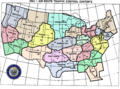 Artccmap.png 752 × 558; 71 KB
-
 Atlantic Oceanic Control.gif 311 × 328; 45 KB
-
 FIR and jurisdictional airspace in Japan.png 1,250 × 1,000; 256 KB
-
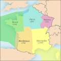 FIR France.svg 801 × 801; 1.07 MB
-
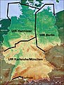
 Fir.png 486 × 564; 22 KB
-
 Firlowerp.jpg 422 × 557; 87 KB
-
 Firupperp.jpg 422 × 557; 86 KB
-
 FirupperpUL.jpg 422 × 557; 66 KB
-
 Flight Information Region (FIR) and Control Area in Japan.pdf 1,752 × 1,239; 435 KB
-
 Flight Information Region (FIR) and Control Area in South Korea.png 538 × 771; 108 KB
-
 Flight Information Regions for Italy-HE.svg 932 × 985; 609 KB
-
 Flight Information Regions for Italy.svg 932 × 985; 607 KB
-
 Jurisdiction airspace and sector of each control center in Japan.png 1,200 × 1,000; 443 KB
-
 Shanwick Map.PNG 1,043 × 822; 559 KB
-
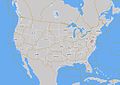 Tfrmap.jpeg 680 × 480; 58 KB


_and_Control_Area_in_South_Korea.png)


