Category:Fields in West Halton
Jump to navigation
Jump to search
Media in category "Fields in West Halton"
The following 24 files are in this category, out of 24 total.
-
 Bishopthorpe - geograph.org.uk - 10818.jpg 640 × 480; 85 KB
-
 Bridge over Halton Drain - geograph.org.uk - 10831.jpg 640 × 480; 120 KB
-
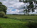
 Fields towards Winterton Beck - geograph.org.uk - 1232757.jpg 640 × 480; 39 KB
-
 Houses on Winteringham Lane - geograph.org.uk - 729110.jpg 640 × 425; 66 KB
-
 Copse near West Halton - geograph.org.uk - 1483081.jpg 640 × 480; 95 KB
-
 Footpath to Alkborough - geograph.org.uk - 1018356.jpg 640 × 427; 72 KB
-
 Footpath to Winteringham - geograph.org.uk - 10816.jpg 640 × 480; 74 KB
-
 Looking towards Whitton - geograph.org.uk - 730755.jpg 640 × 425; 74 KB
-
 Looking West - geograph.org.uk - 56368.jpg 425 × 640; 110 KB
-
 Miles away - geograph.org.uk - 11879.jpg 640 × 480; 120 KB
-
 Near West Halton - geograph.org.uk - 1346897.jpg 640 × 480; 100 KB
-

-
 Public Footpath to Alkborough - geograph.org.uk - 859525.jpg 640 × 480; 373 KB
-
 Public Footpath To West Halton - geograph.org.uk - 1723600.jpg 640 × 480; 40 KB
-
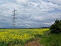
 Pylons near West Halton - geograph.org.uk - 1131603.jpg 640 × 480; 67 KB
-
 Pylons near West Halton - geograph.org.uk - 1346827.jpg 640 × 480; 99 KB
-
 The Footpath to West Halton - geograph.org.uk - 852100.jpg 426 × 640; 114 KB
-
 The Public Footpath to Winteringham - geograph.org.uk - 1346877.jpg 640 × 480; 94 KB
-
 The Road to Whitton - geograph.org.uk - 859542.jpg 640 × 480; 375 KB
-
 Track and pylon - geograph.org.uk - 1310703.jpg 640 × 480; 66 KB
-
 Track towards Barkers Holt - geograph.org.uk - 1233812.jpg 640 × 480; 24 KB
-

-
 View from Winteringham Lane - geograph.org.uk - 861166.jpg 640 × 480; 407 KB
-
 Willow Stump - geograph.org.uk - 10780.jpg 640 × 480; 120 KB


