Category:Feuerwehrgerätehaus (Reuth, Neuendettelsau)
Jump to navigation
Jump to search
| Object location | | View all coordinates using: OpenStreetMap |
|---|
Media in category "Feuerwehrgerätehaus (Reuth, Neuendettelsau)"
The following 4 files are in this category, out of 4 total.
-
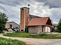 Reuth (Neuendettelsau), Feuerwehrgerätehaus 20240504 130518.jpg 4,000 × 3,000; 2.97 MB
-
 Reuth (Neuendettelsau), Feuerwehrgerätehaus 20240504 130612.jpg 4,000 × 3,000; 2.84 MB
-
 Reuth (Neuendettelsau), Feuerwehrgerätehaus 20240504 130632.jpg 3,344 × 2,016; 4.6 MB
-
 Reuth (Neuendettelsau), Feuerwehrgerätehaus 20240504 130647.jpg 3,000 × 4,000; 2 MB
,_Feuerwehrger%C3%A4tehaus_20240504_130518.jpg)
,_Feuerwehrger%C3%A4tehaus_20240504_130612.jpg)
,_Feuerwehrger%C3%A4tehaus_20240504_130632.jpg)
,_Feuerwehrger%C3%A4tehaus_20240504_130647.jpg)