Category:Fethard, County Tipperary
Jump to navigation
Jump to search
Български: Федард е град в централната южна част на Ирландия, провинция Мънстър, на графство Типърари.
English: Fethard ( east of Cashel. It is situated on the Clashawley River where the R692, R689 and R706 regional roads intersect.
Gaeilge: Baile mór i gContae Thiobraid Árainn is ea Fiodh Ard (an choill ard) ( Béarla: Fethard), agus é suite ar an nGlais Álainn. Tagann fuaimniú an ainm i mBéarla ó /fið ard/ na seanGhaeilge. Tá os cionn 1,300 duine ina gcónaí ann.
town in Munster, Ireland  | |||||
| Upload media | |||||
| Instance of | |||||
|---|---|---|---|---|---|
| Location | South Riding of Tipperary, County Tipperary, Munster, Ireland | ||||
| Area |
| ||||
| Elevation above sea level |
| ||||
 | |||||
Subcategories
This category has the following 10 subcategories, out of 10 total.
A
- Abymill (2 F)
- Allied Irish Bank, Fethard (1 F)
F
- Fethard Town Hall (1 F)
- Fethard town walls (7 F)
H
- Holy Trinity Church, Fethard (1 F)
M
- Madam's Bridge, Fethard (1 F)
- McCarthy's Hotel, Fethard (1 F)
P
- Fethard Priory (30 F)
Media in category "Fethard, County Tipperary"
The following 75 files are in this category, out of 75 total.
-
 Abymill Fethard.png 2,000 × 1,420; 3.28 MB
-
 Abymills plaque.png 2,000 × 1,330; 5.52 MB
-

-

-

-
 Chimney, Fethard - geograph.org.uk - 5889575.jpg 1,024 × 681; 156 KB
-

-
 Clashawley River - geograph.org.uk - 5889553.jpg 1,024 × 681; 235 KB
-
 Clashawley River - geograph.org.uk - 5889555.jpg 1,024 × 681; 228 KB
-
 Clashawley River - geograph.org.uk - 5889569.jpg 1,024 × 681; 233 KB
-
 Clashawley River - geograph.org.uk - 5889572.jpg 1,024 × 681; 223 KB
-
 County Tipperary - Allied Irish Bank - 20210926105306.jpg 2,000 × 1,330; 2.84 MB
-
 Fethard Augustinian Priory sheela-na-gig.png 3,104 × 3,104; 16.68 MB
-
 Fethard Ballroom - geograph.org.uk - 5889600.jpg 1,024 × 681; 128 KB
-
 Fethard Ballroom.jpg 2,000 × 1,276; 2.3 MB
-
 Fethard Castle - geograph.org.uk - 5889545.jpg 681 × 1,024; 210 KB
-
 Fethard Castle - geograph.org.uk - 5889549.jpg 1,024 × 681; 174 KB
-
 Fethard Clashawley River 2012 09 05.jpg 3,504 × 2,336; 6.97 MB
-
 Fethard Condensed Milk Factory.jpg 2,000 × 1,330; 3.49 MB
-
 Fethard Main Street Allied Irish Bank 2012 09 05.jpg 2,787 × 2,145; 3.31 MB
-
 Fethard Main Street Former Parochial House 2012 09 05.jpg 2,975 × 2,198; 4.65 MB
-
 Fethard Main Street Former Parochial House II 2012 09 05.jpg 2,803 × 2,229; 4.18 MB
-
 Fethard North Gate.png 2,744 × 2,000; 7.88 MB
-
 Fethard Pedestrian Bridge crossing the Clashawley River 2012 09 05.jpg 3,366 × 2,252; 6.17 MB
-
 Fethard town wall and churches.jpg 1,280 × 960; 1.14 MB
-
 Fethard town walls - geograph.org.uk - 3036055.jpg 640 × 427; 308 KB
-
 Fethard town walls - geograph.org.uk - 5889560.jpg 1,024 × 681; 197 KB
-
 Fethard Town Walls - geograph.org.uk - 5917748.jpg 1,024 × 768; 187 KB
-
 Fethard town walls - prison - geograph.org.uk - 5889566.jpg 1,024 × 681; 246 KB
-
 Fethard town walls - tower - geograph.org.uk - 5889561.jpg 1,024 × 681; 155 KB
-
 Fethard town walls - tower - geograph.org.uk - 5889574.jpg 681 × 1,024; 166 KB
-
 Fethard town walls - Watergate - geograph.org.uk - 5889550.jpg 1,024 × 681; 221 KB
-
 Fethard town walls - Watergate - geograph.org.uk - 5889559.jpg 1,024 × 681; 171 KB
-
 Fethard, County Tipperary - Holy Trinity Church - 20210926110534.jpg 2,000 × 1,310; 2.82 MB
-
 Fethard, County Tipperary - Madam's Bridge - 20210926110934.jpg 2,000 × 1,330; 3.49 MB
-
 FethardCentre3473.jpg 3,784 × 2,588; 2.33 MB
-
 Footbridge, Clashawley River - geograph.org.uk - 5889563.jpg 1,024 × 681; 152 KB
-
 Footbridge, Clashawley River - geograph.org.uk - 5889567.jpg 1,024 × 681; 186 KB
-
 From the town walls - Fethard, County Tipperary - geograph.org.uk - 6282798.jpg 1,024 × 683; 122 KB
-
 Holy Trinity Church - Fethard, County Tipperary - geograph.org.uk - 6091530.jpg 1,024 × 629; 126 KB
-

-
 House on Watergate St - geograph.org.uk - 5889547.jpg 1,024 × 681; 154 KB
-
 Kiltinan Church sheela wanted poster.png 1,632 × 2,337; 1.86 MB
-
 Madams Bridge - Fethard, County Tipperary - geograph.org.uk - 6086205.jpg 1,024 × 692; 136 KB
-

-
 Main Street - Fethard, County Tipperary - geograph.org.uk - 6091843.jpg 1,024 × 692; 121 KB
-
 North Gate - Fethard, County Tipperary - geograph.org.uk - 6086526.jpg 1,024 × 670; 112 KB
-

-

-
 PJ Lonergans - geograph.org.uk - 5889579.jpg 1,024 × 681; 172 KB
-
 R689, Fethard - geograph.org.uk - 5889593.jpg 1,024 × 586; 116 KB
-
 R689, Fethard - geograph.org.uk - 5889597.jpg 1,024 × 634; 114 KB
-
 R689, R692 junction - geograph.org.uk - 5889584.jpg 1,024 × 681; 142 KB
-
 R692 to Cashel - geograph.org.uk - 5889603.jpg 1,024 × 631; 105 KB
-
 R692, Fethard - geograph.org.uk - 5889542.jpg 1,024 × 681; 125 KB
-
 R706 from Kilsheelan - Fethard, County Tipperary - geograph.org.uk - 6277916.jpg 1,024 × 629; 105 KB
-
 River Clashawley.jpg 2,832 × 2,128; 1.03 MB
-

-

-

-
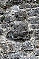 Sheela-na-gig, Fethard - geograph.org.uk - 1392510.jpg 427 × 640; 400 KB
-
 Street scene, Fethard, Co. Tipperary - geograph.org.uk - 207559.jpg 640 × 468; 85 KB
-
 The Castle - geograph.org.uk - 5889577.jpg 681 × 1,024; 191 KB
-
 The Castle Inn - Fethard, County Tipperary - geograph.org.uk - 6091856.jpg 1,024 × 629; 129 KB
-

-
 The Tholsel - Fethard, County Tipperary - geograph.org.uk - 6279788.jpg 1,024 × 689; 117 KB
-
 Towers and walls - Fethard, County Tipperary - geograph.org.uk - 6527345.jpg 1,024 × 634; 104 KB
-

-
 Watergate Bridge - Fethard, County Tipperary - geograph.org.uk - 6086218.jpg 1,024 × 692; 102 KB
-
 Watergate Bridge - geograph.org.uk - 5889551.jpg 1,024 × 681; 180 KB
-

-
 Watergate junction - Fethard, County Tipperary - geograph.org.uk - 6084450.jpg 1,024 × 674; 127 KB
-
 Watergate junction - Fethard, County Tipperary - geograph.org.uk - 6510426.jpg 1,024 × 679; 117 KB
-

-
 North Gate, Fethard , Co. Tipperary - geograph.org.uk - 207572.jpg 640 × 471; 107 KB


