Category:Festung A 4263
Jump to navigation
Jump to search
| Object location | | View all coordinates using: OpenStreetMap |
|---|
Deutsch: A4263 Artilleriewerk Reuenthal
historical museum in Full-Reuenthal (AG), Switzerland  | |||||
| Upload media | |||||
| Instance of |
| ||||
|---|---|---|---|---|---|
| Part of | |||||
| Location | Full-Reuenthal, Zurzach District, Aargau, Switzerland | ||||
| Street address |
| ||||
| Heritage designation | |||||
| Inception |
| ||||
| Date of official opening |
| ||||
| official website | |||||
 | |||||
Subcategories
This category has only the following subcategory.
Media in category "Festung A 4263"
The following 16 files are in this category, out of 16 total.
-
 Beobachtungsbunker 1 der Festung Reuenthal IMG 1427.JPG 3,000 × 2,250; 1.19 MB
-
 Beobachtungsbunker 2 der Festung Reuenthal IMG 1769.JPG 3,000 × 2,250; 1.43 MB
-
 Eingang Festung Reuenthal IMG 1607.jpg 3,000 × 2,250; 1.8 MB
-
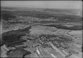 ETH-BIB-Reuenthal, Full, Waldshut-LBS H1-015083.tif 6,467 × 4,459; 82.65 MB
-
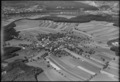 ETH-BIB-Reuenthal-LBS H1-015082.tif 6,496 × 4,445; 82.79 MB
-
 Festung Reuenthal Barcode.png 400 × 400; 914 bytes
-
 G1 aussen Festung Reuenthal IMG 1764.jpg 2,250 × 3,000; 1.92 MB
-
 G2 aussen Festung Reuenthal IMG 1761.jpg 3,000 × 2,250; 1.52 MB
-
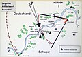
 Grundriss Festung Reuenthal IMG 1609.jpg 3,000 × 2,250; 1.68 MB
-
 Notausgang Festung Reuenthal IMG 1781.jpg 2,250 × 3,000; 1.35 MB
-
 Notausgang Reuenthal.jpg 600 × 430; 76 KB
-
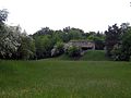
 Reuenthal 2153.JPG 2,000 × 1,500; 2.27 MB
-
 Telefonanschluss Bunker B1 Reuenthal geschlossen.jpg 2,000 × 1,500; 2.91 MB
-
 Telefonanschluss Bunker B1 Reuenthal geöffnet.jpg 2,000 × 1,500; 2.85 MB
-
 Wanderwegweiser Bahnhof Koblenz.JPG 2,000 × 1,500; 1.8 MB
-
 Wirkungsraum Festung Reuenthal IMG 1608.jpg 2,540 × 1,766; 1.15 MB


