Category:Ferry Point, Highland
Jump to navigation
Jump to search
small settlement in Scotland  | |||||
| Upload media | |||||
| Instance of | |||||
|---|---|---|---|---|---|
| Location |
| ||||
 | |||||
Deutsch: Ferry Point ist ein kleiner Weiler am Südufer des Dornoch Firth auf dem Gebiet der Community Council Area von Tain in Schottland. Er liegt an der nordwestlichen Spitze der Halbinsel Ness of Portnaculter, von hier aus verkehrte die eingestellte Fährverbindung Meikle Ferry
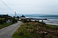
English: Ferry Point is a small hamlet on the southern shores of Dornoch Firth within the community council area of Tain, Scotland. It is located on the northwestern point of Ness of Portnaculter peninsula and marks the southern end of former Meikle Ferry
Media in category "Ferry Point, Highland"
The following 17 files are in this category, out of 17 total.
-
 "Gizzen Briggs" at Ferry Point - geograph.org.uk - 2243663.jpg 640 × 481; 168 KB
-
 Cambuscarrie Bay - geograph.org.uk - 2995854.jpg 640 × 426; 47 KB
-

-
 Curlew near Ferry Point - geograph.org.uk - 2243648.jpg 640 × 481; 191 KB
-
 Dornoch Firth sands, low tide (geograph 3977188).jpg 640 × 483; 68 KB
-
 Edderton Sands from Ness of Portnaculter - geograph.org.uk - 3482402.jpg 1,500 × 877; 1.12 MB
-
 Ferry point (geograph 2058101).jpg 1,000 × 669; 181 KB
-
 Ferry Point - geograph.org.uk - 104240.jpg 640 × 480; 65 KB
-
 Ferry Point, Dornoch Firth - geograph.org.uk - 1801228.jpg 800 × 534; 93 KB
-

-

-
 Meikle Ferry (South) pier - geograph.org.uk - 2567913.jpg 4,000 × 3,000; 2.52 MB
-
 Meikle Ferry Sands - geograph.org.uk - 2221802.jpg 2,560 × 1,920; 1.02 MB
-
 Pier at Ferry Point - geograph.org.uk - 104242.jpg 640 × 480; 69 KB
-
 Retired buoy at Ferry Point - geograph.org.uk - 2243654.jpg 640 × 481; 138 KB
-
 Slipway at Meikle Ferry (south) - geograph.org.uk - 871958.jpg 640 × 480; 78 KB
-
 The slipway at Meikle Ferry (north) - geograph.org.uk - 871939.jpg 640 × 480; 71 KB


.jpg)

.jpg)


_pier_-_geograph.org.uk_-_2567913.jpg)


_-_geograph.org.uk_-_871958.jpg)
_-_geograph.org.uk_-_871939.jpg)