Category:Fero Chorio (Tinos)
Jump to navigation
Jump to search
| Object location | | View all coordinates using: OpenStreetMap |
|---|
human settlement in Greece  | |||||
| Upload media | |||||
| Instance of | |||||
|---|---|---|---|---|---|
| Location |
| ||||
| Population |
| ||||
 | |||||
Media in category "Fero Chorio (Tinos)"
This category contains only the following file.
-
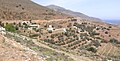 Fero Chorio, Tinos, Greece 2018040912470NP1623.jpg 2,406 × 1,219; 1.2 MB