Category:Fen Line
Jump to navigation
Jump to search
English: The Fen Line (sometimes Fenline without the space) runs from Cambridge in Cambridgeshire to King's Lynn in Norfolk, in East Anglia, England. It is so called because it runs through The Fens.
Railway line in East Anglia connecting Cambridge and Kings Lynn   | |||||
| Upload media | |||||
| Instance of | |||||
|---|---|---|---|---|---|
| Part of |
| ||||
| Location | East of England, England | ||||
| Owned by | |||||
| Operator | |||||
| Terminus | |||||
| |||||
Subcategories
This category has the following 12 subcategories, out of 12 total.
C
- Cambridge North railway station (48 F)
D
- Denver railway station (11 F)
E
K
- King's Lynn railway station (91 F)
L
S
- Stow Bardolph level crossing (9 F)
W
- Waterbeach railway station (32 F)
Media in category "Fen Line"
The following 48 files are in this category, out of 48 total.
-
 Approaching Ely - geograph.org.uk - 1175780.jpg 640 × 429; 62 KB
-
 Black Horse Drove level crossing - geograph.org.uk - 549097.jpg 640 × 480; 75 KB
-
 Box Girder Bridge over the Great Ouse - geograph.org.uk - 587110.jpg 600 × 399; 197 KB
-
 Cambridge to Ely railway track - geograph.org.uk - 6295216.jpg 2,000 × 1,330; 1.94 MB
-
 Diesel loco hauling freight - geograph.org.uk - 2229999.jpg 640 × 480; 137 KB
-
 Ely railway bridge.jpg 4,896 × 3,672; 7.2 MB
-
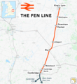 Fen line.png 1,739 × 1,900; 2 MB
-
 Former M&GN Bridge Buttress at South Lynn 1.jpg 7,360 × 4,912; 12.81 MB
-
 Former M&GN Bridge Buttress at South Lynn 2.jpg 7,360 × 4,912; 10.71 MB
-
 Former M&GN Bridge Buttress at South Lynn 3.jpg 7,360 × 4,912; 9.69 MB
-

-

-
 Load of spuds - geograph.org.uk - 1169906.jpg 640 × 480; 82 KB
-

-
 Looking along the track to Watlington Station - geograph.org.uk - 2285469.jpg 2,848 × 2,136; 2.83 MB
-
 M&GN bridge pillar over the Fen Line, graffiti detail.jpg 4,282 × 2,722; 6.54 MB
-
 M&GN bridge pillar over the Fen Line.jpg 4,301 × 2,867; 5.97 MB
-
 MainlineSouthofElyDockJct.jpg 640 × 415; 61 KB
-
 Next station stop will be Littleport - geograph.org.uk - 1721849.jpg 640 × 431; 57 KB
-
 Next stop King's Lynn - geograph.org.uk - 2285452.jpg 2,848 × 2,136; 2.84 MB
-
 Ouse Bridge - geograph.org.uk - 577756.jpg 3,008 × 2,000; 2.91 MB
-

-
 Platelayers hut on the Fen Line, King's Lynn.jpg 3,757 × 2,504; 5.95 MB
-
 Points in the snow - geograph.org.uk - 1144161.jpg 640 × 480; 82 KB
-
 Railway bridge - geograph.org.uk - 1735117.jpg 640 × 480; 73 KB
-
 Railway Bridge - geograph.org.uk - 738115.jpg 640 × 480; 79 KB
-
 Railway Bridge over the Great Ouse - geograph.org.uk - 488088.jpg 639 × 425; 284 KB
-
 Railway bridge over the Polver Drain - geograph.org.uk - 2294157.jpg 2,848 × 2,136; 3.07 MB
-
 Railway bridge over the River Nar - geograph.org.uk - 684742.jpg 3,008 × 2,000; 3.87 MB
-
 Railway crosses the Cut-Off Channel - geograph.org.uk - 1467035.jpg 640 × 480; 62 KB
-
 Railway Line to Ely - geograph.org.uk - 344338.jpg 640 × 480; 100 KB
-
 Railway over Church Road - geograph.org.uk - 1142207.jpg 640 × 480; 99 KB
-
 Railway Track at Campbells Meadow - geograph.org.uk - 4627608.jpg 640 × 480; 491 KB
-

-

-
 Signage at level crossing - geograph.org.uk - 524265.jpg 426 × 640; 140 KB
-
 Single line railway - geograph.org.uk - 3116900.jpg 640 × 480; 113 KB
-
 South Lynn Link Bridge 11.jpg 7,360 × 4,912; 7.76 MB
-
 SPAD Indicator 01.jpg 1,200 × 947; 405 KB
-
 SPAD Indicator L22 - (cropped).jpg 264 × 502; 60 KB
-
 The Ely line - geograph.org.uk - 764596.jpg 640 × 478; 92 KB
-
 The line to Lynn - geograph.org.uk - 4324818.jpg 1,024 × 731; 1.02 MB
-

-

-
 Train near St Peter's Road, Watlington - geograph.org.uk - 2285472.jpg 2,848 × 2,136; 2.85 MB
-
 Various bits of engineering - geograph.org.uk - 1554218.jpg 640 × 480; 125 KB
-

-
 Railway Bridge over the Great Ouse - geograph.org.uk - 663629.jpg 640 × 480; 59 KB


.jpg)


