Category:Farmhouse of the Sieczka family in Zakopane
Jump to navigation
Jump to search
| Object location | | View all coordinates using: OpenStreetMap |
|---|
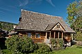
Polski: Zakopane, ul. Kościeliska 52 - chałupa Sieczków (dom dla letników)
 | |||||
| Upload media | |||||
| Location | Zakopane, Tatra County, Lesser Poland Voivodeship, Poland | ||||
|---|---|---|---|---|---|
| Street address |
| ||||
| Heritage designation |
| ||||
 | |||||
Media in category "Farmhouse of the Sieczka family in Zakopane"
The following 4 files are in this category, out of 4 total.
-
 2020 Zakopane Kościeliska 52, 1.jpg 5,328 × 4,000; 12.44 MB
-
 2020 Zakopane Kościeliska 52, 2.jpg 5,328 × 4,000; 10.71 MB
-
 Chałupa Sieczków, Zakopane, A-1135 M 01.jpg 1,800 × 1,200; 1.81 MB
-
 Chałupa Sieczków, Zakopane, A-1135 M 02.jpg 1,800 × 1,200; 1.16 MB


