Category:Farmhouse in Wald, Falkenhorst 160
Jump to navigation
Jump to search
| Object location | | View all coordinates using: OpenStreetMap |
|---|
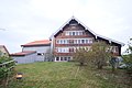
farmhouse in Wald in the canton of Appenzell Innerrhoden, Switzerland  | |||||
| Upload media | |||||
| Instance of | |||||
|---|---|---|---|---|---|
| Part of | |||||
| Location |
| ||||
| Street address |
| ||||
| Heritage designation | |||||
 | |||||
Media in category "Farmhouse in Wald, Falkenhorst 160"
The following 2 files are in this category, out of 2 total.
-
 Falkenhorst 160.jpg 6,240 × 4,160; 13.83 MB
-
 Falkenhorst160.jpg 4,608 × 3,456; 2.71 MB
