Category:Farmhouse Unterniesenberg 45, Kallern
Jump to navigation
Jump to search
| Object location | | View all coordinates using: OpenStreetMap |
|---|
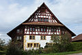
farmhouse in Kallern im Kanton Aargau, Schweiz  | |||||
| Upload media | |||||
| Instance of | |||||
|---|---|---|---|---|---|
| Part of | |||||
| Location | Kallern, Muri District, Aargau, Switzerland | ||||
| Street address |
| ||||
| Heritage designation | |||||
| Inception |
| ||||
 | |||||
Media in category "Farmhouse Unterniesenberg 45, Kallern"
This category contains only the following file.
-
 Kallern-Bauernhaus.jpg 1,200 × 800; 969 KB