Category:Farmers Arms, Frankby
Jump to navigation
Jump to search
| Object location | | View all coordinates using: OpenStreetMap |
|---|
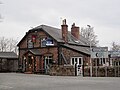
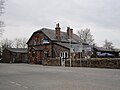
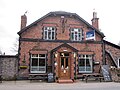
Now renamed as The Old Rathbone.
Media in category "Farmers Arms, Frankby"
The following 10 files are in this category, out of 10 total.
-
 Farmer's Arms Public House, Frankby - geograph.org.uk - 689932.jpg 640 × 409; 97 KB
-
 Farmers Arms, Frankby (1).JPG 4,320 × 3,240; 2.98 MB
-
 Farmers Arms, Frankby (2).JPG 4,320 × 3,240; 3.09 MB
-
 Farmers Arms, Frankby (3).JPG 4,320 × 3,240; 3.06 MB
-
 Farmers Arms, Frankby (4).JPG 4,320 × 3,240; 3.13 MB
-
 Farmers Arms, Frankby (5).JPG 4,320 × 3,240; 2.9 MB
-
 Farmers Arms, Frankby (6).JPG 3,240 × 4,320; 3.19 MB
-
 Farmers Arms, Frankby 2016.jpg 4,656 × 2,640; 4.52 MB
-
 Farmers Arms, Frankby through the gate - geograph.org.uk - 689931.jpg 640 × 405; 101 KB
-
 The Farmers Arms, Frankby - IMG 1123.JPG 4,320 × 3,240; 2.34 MB

.JPG)
.JPG)
.JPG)
.JPG)
.JPG)
.JPG)


