Category:Far Cotton
Jump to navigation
Jump to search
English: Far Cotton is an area of Northampton, in the civil parish of Far Cotton and Delapre, in the Northampton district, in the county of Northamptonshire, England.
suburb of Northampton, United Kingdom | |||||
| Upload media | |||||
| Instance of | |||||
|---|---|---|---|---|---|
| Location | Far Cotton and Delapre, Northampton, Northamptonshire, East Midlands, England | ||||
 | |||||
Media in category "Far Cotton"
The following 12 files are in this category, out of 12 total.
-
 An old house at Far Cotton - geograph.org.uk - 513385.jpg 600 × 403; 35 KB
-
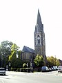 Corner of St. Mary's church, Far Cotton, Northampton.jpg 2,736 × 3,648; 3.33 MB
-
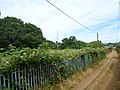 Far Cotton - geograph.org.uk - 4044042.jpg 640 × 480; 74 KB
-
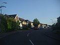 Lancaster Way, Far Cotton - geograph.org.uk - 3073445.jpg 1,600 × 1,200; 499 KB
-
 Lancaster Way, Far Cotton - geograph.org.uk - 3073447.jpg 1,600 × 1,200; 530 KB
-
 Roundabout on Towcester Road, Far Cotton - geograph.org.uk - 3073452.jpg 1,600 × 1,200; 558 KB
-
 Roundabout on Towcester Road, Far Cotton - geograph.org.uk - 3073458.jpg 1,600 × 1,200; 522 KB
-
 Telephone Exchange, Far Cotton (1) - geograph.org.uk - 3995831.jpg 3,072 × 2,304; 1.75 MB
-
 Telephone Exchange, Far Cotton (2) - geograph.org.uk - 3995843.jpg 3,072 × 2,304; 1.77 MB
-
 Telephone Exchange, Far Cotton (3) - geograph.org.uk - 3995861.jpg 3,072 × 2,304; 1.74 MB
-
 Towcester Road, Far Cotton - geograph.org.uk - 3073645.jpg 1,600 × 1,200; 649 KB
-
 Towcester Road, Far Cotton - geograph.org.uk - 3073646.jpg 1,600 × 1,200; 606 KB


_-_geograph.org.uk_-_3995831.jpg)
_-_geograph.org.uk_-_3995843.jpg)
_-_geograph.org.uk_-_3995861.jpg)

