Category:FFH-Gebiet Östliches Riffgebiet Orlatal
Jump to navigation
Jump to search
| Diese Kategorie repräsentiert ein Schutzgebiet nach Naturschutzrecht in Deutschland. |
|---|
| Diese Kategorie wurde nach einem klaren Schema angelegt, sie sollte nicht verschoben, gelöscht oder umkategorisiert werden. Sie ist unter anderem in dieser Uploadkarte hinterlegt. Beschreibung und Hintergründe auf der Seite des Wikiprojekts |
| Foto zu Wiki Loves Earth hochladen! - Seite von Wiki Loves Earth Deutschland |
protected area in the European Union defined by the habitats directive in Thüringen, Germany  | |||||
| Upload media | |||||
| Instance of | |||||
|---|---|---|---|---|---|
| Location | Saale-Orla-Kreis, Thuringia, Germany | ||||
| Applies to jurisdiction | |||||
| Inception |
| ||||
| Area |
| ||||
 | |||||
Deutsch: FFH-Gebiet DE-5236-302 „Östliches Riffgebiet Orlatal“ im Saale-Orla-Kreis, Thüringen
Media in category "FFH-Gebiet Östliches Riffgebiet Orlatal"
The following 15 files are in this category, out of 15 total.
-
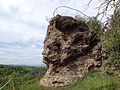
 Felsformation am Totenstein.jpg 3,264 × 2,448; 4.28 MB
-
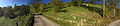
 FFH-Gebiet Östliches Riffgebiet Orlatal (Mühlengrund).jpg 5,280 × 2,970; 12.48 MB
-
 Mühlengrund-Orla.jpg 2,848 × 4,288; 5.05 MB
-
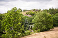
 Nordost-Sicht auf das FFH-Gebiet Östliches Riffgebiet Orlatal.jpg 5,280 × 2,970; 13.96 MB
-
 Totenstein 2014-05-10.jpg 2,048 × 1,536; 1.42 MB
-
 Totenstein Pano.jpg 13,632 × 2,936; 31.89 MB
-
 Totenstein und Koleschhöhle über dem FFH-Gebiet Östliches Riffgebiet Orlatal.jpg 4,000 × 2,250; 9.13 MB
-
 Totenstein-Hügel.jpg 2,448 × 2,448; 2.74 MB
-
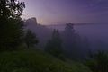 Totenstein-mühlengrund-sunrise.jpg 2,000 × 1,328; 1.34 MB
-
 Totenstein-mühlengrund-sunrise2.jpg 2,000 × 1,328; 1.7 MB
-
 Totenstein-mühlengrund.jpg 2,000 × 1,328; 2.33 MB
-
 Totenstein2.jpg 4,288 × 2,848; 8.94 MB
-
 Totenstein5.jpg 2,832 × 3,776; 7.05 MB
-
 Totenstein6.jpg 2,448 × 2,448; 4.63 MB
-
 Ziegenrück-waterfall.jpg 2,000 × 1,328; 2.03 MB

.jpg)


