Category:Fürstenbau (Bad Imnau)
Jump to navigation
Jump to search
| Object location | | View all coordinates using: OpenStreetMap |
|---|
 | |||||
| Upload media | |||||
| Instance of | |||||
|---|---|---|---|---|---|
| Location | Haigerloch, Zollernalb, Tübingen Government Region, Baden-Württemberg, Germany | ||||
| Street address |
| ||||
| Heritage designation | |||||
| Inception |
| ||||
 | |||||
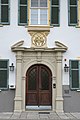
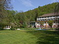
Deutsch: Fürstenbau des ehemaligen Stahlbads in Bad Imnau
Media in category "Fürstenbau (Bad Imnau)"
The following 11 files are in this category, out of 11 total.
-
 Bad Imnau Fürstenbau 897.jpg 3,264 × 4,896; 10.21 MB
-
 Bad Imnau Fürstenbau 898.jpg 4,896 × 3,264; 10.09 MB
-
 Bad Imnau Fürstenbau 899.jpg 3,264 × 4,896; 10.65 MB
-
 Bad Imnau-Fürstenbau und Kursaal84874.jpg 3,456 × 2,592; 3.46 MB
-
 Bad Imnau-Fürstenbau84868.jpg 3,456 × 2,592; 3.48 MB
-
 Bad Imnau-Fürstenbau84871.jpg 2,592 × 3,456; 3.3 MB
-
 Bad Imnau-Fürstenbau84880.jpg 2,592 × 3,456; 3.22 MB
-
 Bad Imnau-Fürstenbau84883.jpg 3,456 × 2,592; 3.26 MB
-
 Bad Imnau-Fürstenbau84886.jpg 2,592 × 3,456; 3.1 MB
-
 Hotel Fürstenhof im Kurpark Bad Imnau - panoramio (1).jpg 3,264 × 1,632; 2.17 MB
-
 Hotel Fürstenhof im Kurpark Bad Imnau - panoramio.jpg 3,264 × 2,448; 3.44 MB


.jpg)
