Category:Fürst-Pückler-Weg
Jump to navigation
Jump to search
English: Cycle path Fürst-Pückler-Weg in Brandenburg, Germany
Deutsch: Radweg Fürst-Pückler-Weg in Brandenburg, Deutschland
 | |||||
| Upload media | |||||
| Instance of | |||||
|---|---|---|---|---|---|
| Location |
| ||||
| official website | |||||
| |||||
Subcategories
This category has the following 3 subcategories, out of 3 total.
E
G
Media in category "Fürst-Pückler-Weg"
The following 31 files are in this category, out of 31 total.
-
 Biotopverbund Spreeaue nature reserve, Cottbus (former irrigation fields at CB-Saspow).png 2,263 × 1,674; 6.36 MB
-
 Cycling routes at Lakoma (Cottbus).png 2,346 × 1,566; 6.45 MB
-
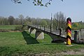 Forst - Ehemalige Neißebrücke 0001.jpg 1,200 × 803; 263 KB
-
 Forst - Kegeldamm 0001.jpg 1,200 × 803; 280 KB
-
 Forst - Schilder Radweg.jpg 1,200 × 833; 226 KB
-
 Fürst-Pückler-Radweg alongside Priorgraben in Cottbus-Sachsendorf.png 2,464 × 1,632; 8.55 MB
-
 Fürst-Pückler-Weg Karte Etappe 1.png 1,005 × 910; 737 KB
-
 Fürst-Pückler-Weg Karte Etappe 8.png 795 × 514; 337 KB
-
 Groß Schacksdorf - Heimatstube 0001.jpg 1,200 × 803; 533 KB
-
 Guhrow 001.jpg 1,200 × 803; 519 KB
-
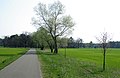 Haasow - Radweg östlich des Dorfes 0001.jpg 1,200 × 785; 267 KB
-
 Jocksdorf - Fürst-Pückler-Weg 0001.jpg 1,200 × 803; 250 KB
-
 Jocksdorf - Fürst-Pückler-Weg 0002.jpg 1,200 × 803; 344 KB
-
 Klinge - Alte Eiche 0001.jpg 834 × 1,200; 286 KB
-
 Klinge - Aussicht auf den rekultivierten Tagebau 0001.jpg 1,200 × 803; 253 KB
-
 Klinge - Freilichtmuseum Zeitsprung 0001.jpg 1,200 × 705; 366 KB
-
 Klinge - Raubrittertor 0001.jpg 1,200 × 803; 400 KB
-
 Kutzeburger Weg 2.png 2,592 × 1,944; 9.68 MB
-
 Kutzeburger Weg.png 2,592 × 1,944; 8.66 MB
-
 Markgrafenmühle 0001.jpg 803 × 1,200; 441 KB
-
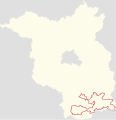 Positionskarte der Radroute Fürst-Pückler-Weg in Brandenburg.svg 2,905 × 3,000; 216 KB
-
 Positionskarte der Radroute Fürst-Pückler-Weg in Sachsen.svg 3,000 × 2,273; 282 KB
-
 Rapsfelder bei Drehnow 0042.jpg 1,200 × 797; 288 KB
-
 Rundwanderweg Cottbus-Sachsendorf (stage 4).png 2,464 × 1,632; 8.51 MB
-
 Rundwanderweg Cottbus-Sachsendorf (stage 6).png 1,632 × 2,464; 7.85 MB
-
 Schilder Radwege Spreeaue 0001.jpg 900 × 681; 286 KB
-
 Schloss Zinnitz Mittelrisalit.JPG 3,648 × 2,736; 1.72 MB
-
 Sign post at Lakoma (Cottbus).png 2,443 × 1,603; 3.46 MB
-
 Sign post at Lakoma 2 (Cottbus).png 2,464 × 1,632; 3.03 MB
-
 Volkspark Cottbus, Madlower Schluchten (paved cycling route).png 2,592 × 1,944; 11.28 MB
-
 Volkspark Cottbus, sign post at Jubiläumsbrücke.png 2,592 × 1,944; 9.51 MB
.png)
.png)


.png)
.png)


.png)
.png)
.png)
