Category:Fänneslunda-Grovare kyrka
Jump to navigation
Jump to search
| Object location | | View all coordinates using: OpenStreetMap |
|---|
church building in Ulricehamn Municipality, Västra Götaland County, Sweden  | |||||
| Upload media | |||||
| Instance of | |||||
|---|---|---|---|---|---|
| Location | Ulricehamn Municipality, Västra Götaland County, Sweden | ||||
| Diocese | |||||
| Has use |
| ||||
| Occupant | |||||
| Heritage designation |
| ||||
 | |||||
|
This is a category about an ecclesiastical monument in Sweden, number 21300000003210 in the RAÄ buildings database.
|
|
This is a category about a protected building in Sweden, number 21400000443872 in the RAÄ buildings database.
|
Subcategories
This category has the following 2 subcategories, out of 2 total.
F
- Fänneslunda kyrkoruin (69 F)
G
- Grovare kyrkoruin (35 F)
Media in category "Fänneslunda-Grovare kyrka"
The following 36 files are in this category, out of 36 total.
-
 Fänneslunda kyrka - KMB - 16000200155971.jpg 803 × 600; 60 KB
-
 Fänneslunda kyrka - KMB - 16000200155972.jpg 877 × 600; 106 KB
-
 Fänneslunda kyrka - KMB - 16000200155973.jpg 848 × 600; 76 KB
-
 Fänneslunda kyrka - KMB - 16000200155974.jpg 602 × 600; 46 KB
-
 Fänneslunda kyrka - KMB - 16000200155975.jpg 933 × 600; 83 KB
-
 Fänneslunda kyrka - KMB - 16000200155976.jpg 931 × 600; 69 KB
-
 Fänneslunda kyrka - KMB - 16000200155977.jpg 462 × 600; 63 KB
-
 Fänneslunda kyrka - KMB - 16000200155978.jpg 890 × 600; 89 KB
-
 Fänneslunda kyrka - KMB - 16000200155979.jpg 438 × 600; 41 KB
-
 Fänneslunda kyrka - KMB - 16000200155980.jpg 486 × 600; 58 KB
-
 Fänneslunda kyrka - KMB - 16000200155982.jpg 431 × 600; 63 KB
-
 Fänneslunda kyrka - KMB - 16000200155983.jpg 427 × 600; 57 KB
-
 Fänneslunda kyrka - KMB - 16000200155984.jpg 446 × 600; 25 KB
-
 Fänneslunda kyrka - KMB - 16000200155985.jpg 537 × 600; 97 KB
-
 Fänneslunda kyrka - KMB - 16000200155986.jpg 442 × 600; 29 KB
-
 Fänneslunda kyrka - KMB - 16000200155988.jpg 799 × 600; 68 KB
-
 Fänneslunda kyrka - KMB - 16000200155989.jpg 628 × 600; 82 KB
-
 Fänneslunda kyrka - KMB - 16000200155990.jpg 439 × 600; 24 KB
-
 Fänneslunda kyrka - KMB - 16000200155992.jpg 431 × 600; 25 KB
-
 Fänneslunda kyrka - KMB - 16000200155994.jpg 857 × 600; 55 KB
-
 Fänneslunda kyrka - KMB - 16000200155995.jpg 427 × 600; 29 KB
-
 Fänneslunda kyrka - KMB - 16000200155996.jpg 435 × 600; 74 KB
-
 Fänneslunda kyrka Grovare dopfunt 1.jpg 1,788 × 610; 724 KB
-
 Fänneslunda kyrka Grovare dopfunt 2.jpg 1,784 × 614; 768 KB
-

-
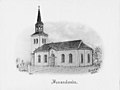
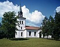 Fänneslunda-Grovare kyrka 1980.jpg 992 × 785; 730 KB
-
 Fänneslunda-krucifix-borås-mus-1200-2a-halv.jpg 371 × 498; 33 KB
-
 Grovare kyrkoruin - KMB - 16000200155862.jpg 430 × 600; 28 KB
-
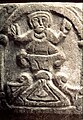
 Grovare-Andreasgruppen-ca1200-agnus-dei-guds-lamm.jpg 376 × 503; 60 KB
-
 Grovare-Andreasgruppen-ca1200-livsträd-dopscen.jpg 564 × 361; 70 KB
-
 Grovare-Andreasgruppen-ca1200-livsträd-fågel.jpg 549 × 370; 68 KB
-
 Grovare-Andreasgruppen-ca1200-mikael-draken.jpg 370 × 534; 69 KB
-
 Grovare-andreasgruppen-ca1200-sandst-lk-shm.jpg 373 × 500; 49 KB
-
 Grovare-Andreasgruppen-ca1200-två-präster.jpg 561 × 374; 76 KB
-
 Grovare-Andreasgruppen-jesu-dop-baptisteri-kanske.jpg 370 × 537; 69 KB
-
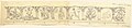 Grovare-dopfunt-teckning-av-Lars-Kennerstedt-1932.jpg 7,985 × 1,759; 1.42 MB


