Category:Ewart Road bridge, Seaforth
Jump to navigation
Jump to search
| Object location | | View all coordinates using: OpenStreetMap |
|---|
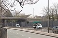
Road bridge over the A5036 Princess Way in Seaforth, Merseyside.
Media in category "Ewart Road bridge, Seaforth"
The following 6 files are in this category, out of 6 total.
-
 Ewart Road Bridge, Seaforth 1.jpg 4,929 × 3,400; 21.43 MB
-
 Ewart Road Bridge, Seaforth 2.jpg 4,997 × 3,406; 20.98 MB
-
 Ewart Road Bridge, Seaforth 3.jpg 4,814 × 2,844; 18.59 MB
-
 Ewart Road bridge, Seaforth 4.jpg 5,117 × 3,341; 18.46 MB
-
 Ewart Road bridge, Seaforth 5.jpg 5,101 × 3,329; 19.62 MB
-
 Ewart Road bridge, Seaforth 6.jpg 5,033 × 2,976; 17.48 MB


