<nowiki>Dorfkirche Dittersdorf: Kirche (mit Ausstattung),Kirchhof mit Einfriedungsmauer und Kirchhofstor,Aufbahrungshalle,drei Grabmaleund frei stehender Glockenturm Kirchsteig -; Evangelische Pfarrkirche Dittersdorf; church building in Amtsberg, Germany; Kirche: barocker Saalbau mit Dachreiter, baugeschichtlich, ortsgeschichtlich und ortsbildprägend von Bedeutung. Kanzelaltar: von Chr. Suttinger, Holz, Kirche: Saalbau 1680, Dachreiter 1732, Grabstätten: Familie Schuncke um 1900, Plastik vermutli; церква в Німеччині; kerkgebouw in Duitsland</nowiki>


 2014-12 Kirche-Dittersdorf Amtsberg 01.jpg 1,998 × 3,000; 8.31 MB
 2014-12 Kirche-Dittersdorf Amtsberg 02.jpg 1,871 × 2,397; 4.69 MB
 2014-12 Kirche-Dittersdorf Amtsberg 03.jpg 3,036 × 2,566; 7.17 MB
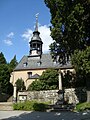 Kirche Dittersdorf.jpg 1,944 × 2,592; 847 KB

