Category:Evangelische Kirche in Elend (Harz)
Jump to navigation
Jump to search
|
Evangelische Kirche in Elend (Harz) has an entry on OpenStreetMap (show). |
| Object location | | View all coordinates using: OpenStreetMap |
|---|
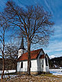
church building in Oberharz am Brocken, Germany  ,_Altar.jpg) | |||||
| Upload media | |||||
| Instance of | |||||
|---|---|---|---|---|---|
| Location | Oberharz am Brocken, Harz District, Saxony-Anhalt, Germany | ||||
| Heritage designation | |||||
| Inception |
| ||||
| Religion or worldview | |||||
| official website | |||||
 | |||||
This is the category of the Saxony-Anhalt Kulturdenkmal (cultural heritage monument) with the ID 09400832 (Wikidata)
|
Media in category "Evangelische Kirche in Elend (Harz)"
The following 27 files are in this category, out of 27 total.
-
 20010202101NR Elend (Harz) Holzkirche.jpg 2,507 × 1,478; 4.16 MB
-
 20010202151NR Elend (Harz) Holzkirche.jpg 2,113 × 1,462; 3.29 MB
-
 Dorfkirche Elend.jpg 3,460 × 2,307; 6.54 MB
-
 Elend, die Kleinste Holzkirche Dm IMG 5127 2018-07-05 15.36.jpg 5,184 × 2,776; 9.17 MB
-
 Elend, die Kleinste Holzkirche Dm IMG 5178 2018-07-06 10.10.jpg 4,524 × 3,050; 7.84 MB
-
 Holzkirche Elend, Sanierung 01.jpg 850 × 709; 143 KB
-
 Holzkirche Elend, Sanierung 02.jpg 850 × 709; 127 KB
-
 Holzkirche Elend, Sanierung 03.jpg 567 × 1,008; 84 KB
-
 Holzkirche Elend, Sanierung 04.jpg 1,008 × 567; 151 KB
-
 Holzkirche Elend, Sanierung 05.jpg 894 × 624; 95 KB
-
 Holzkirche Elend, Sanierung 06.jpg 885 × 624; 96 KB
-
 Holzkirche Elend, Sanierung 07.jpg 567 × 747; 92 KB
-
 Holzkirche Elend, Sanierung 08.jpg 938 × 601; 192 KB
-
 Holzkirche Elend, Sanierung 09.jpg 3,931 × 2,362; 4.67 MB
-
 Kirche Akustikpfad Rocken am Brocken 2018.jpg 6,000 × 4,000; 5.99 MB
-
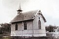 Kirche Elend (Harz) um 1900.jpg 2,736 × 1,824; 1.33 MB
-
 Kirche Elend (Harz), Altar.jpg 2,432 × 3,648; 2.3 MB
-
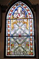
 Kirche Elend (Harz), Fenster Johannes.jpg 1,727 × 2,590; 1.7 MB
-
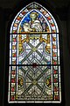
 Kirche Elend (Harz), Fenster Lucas.jpg 1,627 × 2,440; 1.36 MB
-
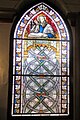
 Kirche Elend (Harz), Fenster Marcus.jpg 1,609 × 2,413; 1.57 MB
-
 Kirche Elend (Harz), Fenster Matthaeus.jpg 1,654 × 2,481; 1.56 MB
-
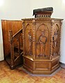 Kirche Elend (Harz), Kanzel.jpg 2,238 × 2,859; 1.43 MB
-
 Kirche Elend (Harz), Orgel.jpg 2,577 × 2,069; 1.45 MB
-
 Kirche Elend Harz 1.jpg 3,264 × 2,176; 7.38 MB
-
 Kirche Elend Harz 2.jpg 3,264 × 2,176; 6.88 MB
-
 KircheElend.jpg 3,276 × 2,449; 1.49 MB
-
 KircheElendOst.jpg 3,456 × 4,608; 5.34 MB
_Holzkirche.jpg)
_Holzkirche.jpg)


_um_1900.jpg)
,_Fenster_Johannes.jpg)
,_Fenster_Lucas.jpg)
,_Fenster_Marcus.jpg)
,_Fenster_Matthaeus.jpg)
,_Kanzel.jpg)
,_Orgel.jpg)


