Category:Evangelische Kirche Vorst (Tönisvorst)
Jump to navigation
Jump to search
| Object location | | View all coordinates using: OpenStreetMap |
|---|
| Upload media | |||||
| Instance of | |||||
|---|---|---|---|---|---|
| Location | North Rhine-Westphalia, Germany | ||||
 | |||||
Media in category "Evangelische Kirche Vorst (Tönisvorst)"
The following 4 files are in this category, out of 4 total.
-
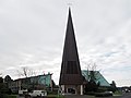
 2020 03 19 Ev. Kirchengemeinde Vorst (Tönisvorst) (1).jpg 4,608 × 3,456; 1.57 MB
-
 2020 03 19 Ev. Kirchengemeinde Vorst (Tönisvorst) (2).jpg 4,608 × 3,456; 999 KB
-
 2020 03 19 Ev. Kirchengemeinde Vorst (Tönisvorst) (5).jpg 4,608 × 3,456; 1.74 MB
-
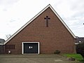
 2020 03 19 Ev. Kirchengemeinde Vorst (Tönisvorst) (6).jpg 3,456 × 4,608; 1.29 MB
_(1).jpg)
_(2).jpg)
_(5).jpg)
_(6).jpg)