Category:Evangelische Kirche Schlatt
Jump to navigation
Jump to search
| Object location | | View all coordinates using: OpenStreetMap |
|---|
 | |||||
| Upload media | |||||
| Instance of | |||||
|---|---|---|---|---|---|
| Location | |||||
| Street address |
| ||||
| Heritage designation | |||||
 | |||||
|
This is a category about a cultural property of national significance in Switzerland with KGS number 11040
|
Media in category "Evangelische Kirche Schlatt"
The following 3 files are in this category, out of 3 total.
-
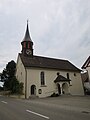 Kirche Schlatt TG 1.jpg 3,000 × 4,000; 1.86 MB
-
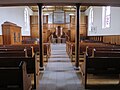 Kirche Schlatt TG 2.JPG 4,000 × 3,000; 2.99 MB
-
 Schlatt, Reformierte Kirche.jpg 2,894 × 2,232; 6.05 MB

