Category:Evangelische Kirche Dauborn
Jump to navigation
Jump to search
This is the category of the Hessian Kulturdenkmal (cultural monument) with the ID 51295 (Wikidata)
|
| Object location | | View all coordinates using: OpenStreetMap |
|---|
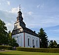
church building in Dauborn, Germany  | |||||
| Upload media | |||||
| Instance of | |||||
|---|---|---|---|---|---|
| Location | Dauborn, Hünfelden, Limburg-Weilburg, Giessen Government Region, Hesse, Germany | ||||
| Street address |
| ||||
| Heritage designation | |||||
 | |||||
Subcategories
This category has the following 2 subcategories, out of 2 total.
G
- Grab Feller (Dauborn) (2 F)
K
- Kriegerdenkmal (Dauborn) (5 F)
Media in category "Evangelische Kirche Dauborn"
The following 5 files are in this category, out of 5 total.
-
 Dauborn Kirche.jpg 3,348 × 2,580; 4.69 MB
-
 Dauborn, Evangelische Kirche (1).jpg 5,214 × 4,521; 15.9 MB
-
 Dauborn, Evangelische Kirche.jpg 5,297 × 4,879; 15.64 MB
-
 Eine von vier Glocken im Dauborner Kirchturm.jpg 3,376 × 6,000; 11 MB
-
 Orgel erbaut 1830-32 von Daniel Raßmann aus Mörtau.jpg 6,016 × 4,000; 5.64 MB
.jpg)


