Category:Evangelische Kirche Bornheim
Jump to navigation
Jump to search
| Object location | | View all coordinates using: OpenStreetMap |
|---|
church  | |||||
| Upload media | |||||
| Instance of | |||||
|---|---|---|---|---|---|
| Location | Bornheim, Rhein-Sieg District, Cologne Government Region, North Rhine-Westphalia, Germany | ||||
| Heritage designation | |||||
 | |||||
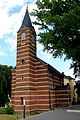
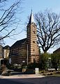
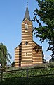
| This category shows a heritage building in Germany, located in the North Rhine-Westphalian city Bornheim (Rheinland) (no. 27). |
Media in category "Evangelische Kirche Bornheim"
The following 15 files are in this category, out of 15 total.
-
 160328 Evangelische Kirche Bornheim 02.jpg 2,630 × 3,267; 4.36 MB
-
 160328 Evangelische Kirche Bornheim 03.jpg 4,021 × 2,655; 6.11 MB
-
 160328 Evangelische Kirche Bornheim 06.jpg 2,625 × 4,090; 6.59 MB
-
 160328 Evangelische Kirche Bornheim 07.jpg 2,574 × 4,084; 6.24 MB
-
 160328 Evangelische Kirche Bornheim 08.jpg 2,661 × 3,900; 6.72 MB
-
 1866 - 2016. Alte u. neue Evangelische Kirche an der Königstraße in Bornheim.jpg 4,836 × 3,788; 11.42 MB
-
 Alte evangelische Kirche Bornheim.JPG 2,848 × 4,272; 6.76 MB
-
 Bornheim alte evangelische Kirche.jpg 1,616 × 2,256; 2.48 MB
-
 Bornheim Evangelische Kirche (01).jpg 3,080 × 4,808; 4.01 MB
-
 Bornheim Evangelische Kirche (02).jpg 2,560 × 3,736; 3.01 MB
-
 Bornheim Evangelische Kirche (03).jpg 3,480 × 4,784; 3.74 MB
-
 Bornheim Evangelische Kirche (04).jpg 3,712 × 4,800; 3.81 MB
-
 Bornheim Evangelische Kirche (05).jpg 3,848 × 4,984; 4.27 MB
-
 Bornheim Evangelische Kirche (06).jpg 3,745 × 4,491; 4.15 MB
-
 Bornheim Evangelische Kirche (07).jpg 3,472 × 3,848; 2.57 MB


.jpg)
.jpg)
.jpg)
.jpg)
.jpg)
.jpg)
.jpg)
Categories:
- Churches in Bornheim (Rheinland)
- Cultural heritage monuments in Bornheim and Botzdorf
- Königstraße (Bornheim, Rheinland)
- 1860s architecture in Bornheim (Rheinland)
- Churches in North Rhine-Westphalia built in 1866
- Protestant churches in Rhein-Sieg-Kreis
- Churches in Kirchenkreis Bonn
- Paul Richard Thomann
- Striped facades
- Aisleless churches in Regierungsbezirk Köln
- 19th-century churches in Regierungsbezirk Köln