Category:Evangelische Kirche (Mixdorf)
Jump to navigation
Jump to search
| Object location | | View all coordinates using: OpenStreetMap |
|---|
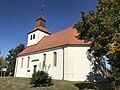
church building in Brandenburg state, Germany  | |||||
| Upload media | |||||
| Instance of | |||||
|---|---|---|---|---|---|
| Location | Mixdorf, Oder-Spree District, Brandenburg, Germany | ||||
| Heritage designation | |||||
 | |||||
This is the category of the Brandenburger Baudenkmal (cultural heritage monument) with the ID 09115025 (Wikidata)
|
Media in category "Evangelische Kirche (Mixdorf)"
The following 11 files are in this category, out of 11 total.
-
 Dorfkirche Mixdorf Nordostansicht.jpg 3,024 × 4,032; 2.57 MB
-
 Dorfkirche Mixdorf Nordwestansicht.jpg 3,024 × 4,032; 2.13 MB
-
 Dorfkirche Mixdorf Ostansicht.jpg 4,032 × 3,024; 3.81 MB
-
 Dorfkirche Mixdorf Südansicht.jpg 4,032 × 3,024; 2.33 MB
-
 Dorfkirche Mixdorf Südostansicht.jpg 4,032 × 3,024; 3.41 MB
-
 Dorfkirche Mixdorf Südportal.jpg 4,032 × 3,024; 2.11 MB
-
 Dorfkirche Mixdorf Südwestansicht.jpg 4,032 × 3,024; 2.4 MB
-
 Dorfkirche Mixdorf Westansicht.jpg 3,024 × 4,032; 1.74 MB
-
 Kirche Mixdorf Schlaubetal 2005.jpg 4,048 × 3,040; 1.86 MB
-
 Kirche Mixdorf Schlaubetal.JPG 2,408 × 3,487; 2.85 MB
-
 Mixdorf - Dorfkirche - panoramio.jpg 640 × 480; 75 KB


