Category:Ethnographic maps of Transleithania
Jump to navigation
Jump to search
Subcategories
This category has the following 2 subcategories, out of 2 total.
Media in category "Ethnographic maps of Transleithania"
The following 13 files are in this category, out of 13 total.
-
 Ethnic Germans in Hungary and parts of adjacent Austrian territories.JPG 3,930 × 2,842; 4.68 MB
-
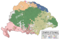 Ethnic Map of Hungary 1910 with Counties and Towns.png 6,208 × 4,104; 1.53 MB
-
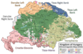 Ethnic Map of Hungary 1910 with Counties.png 6,208 × 4,104; 1.41 MB
-
 Ethno Hung.1910.png 1,103 × 1,039; 473 KB
-
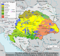
 Hungary-ethnic groups.jpg 2,913 × 2,250; 2.18 MB
-
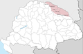 Magyar Ruthenia 1867-1918.png 1,286 × 845; 297 KB
-
 Magyarorszag 1920.png 1,140 × 774; 188 KB
-
 Magyars (Hungarians) in Hungary, census 1890.jpg 1,064 × 800; 760 KB
-
 Magyars in Austro-Hungarian Empire 1911.gif 967 × 519; 385 KB
-
 Rusíni 1880.png 3,508 × 2,204; 678 KB
-
 Trianon consequences.png 1,140 × 774; 192 KB
-
 Walachians (Romanians) in Hungary, census 1890.jpg 1,062 × 789; 654 KB
-
 معاهدة تريانون.png 1,140 × 774; 183 KB


_in_Hungary,_census_1890.jpg)


_in_Hungary,_census_1890.jpg)
