Category:Escalante Route
Jump to navigation
Jump to search
Grand Canyon hiking trail  | |||||
| Upload media | |||||
| Instance of | |||||
|---|---|---|---|---|---|
| Located in protected area | |||||
| Location | Arizona | ||||
 | |||||
English: The (Colorado River, unmaintained trail route), en:Escalante Route, South Rim, where Grand Canyon, East Rim, becomes the South Rim. The route is on the southeast & south of the Colorado River-(as it then flows due-west) from the mileage points, (off upstream, Desert View (Grand Canyon) to north of Zuni Point, downstream):
- (start/end)
Tanner Rapids-(mile 68.5), NNW of Desert View (w/Tanner Canyon)
Unkar Rapid-(mile 72.5)
Nevill Rapid-(75.5)
Hance Rapids-(mile 76.6), due-north, Zuni Point
(start/end)
Media in category "Escalante Route"
The following 3 files are in this category, out of 3 total.
-
 Overlook over the Colorado.JPG 2,576 × 1,689; 1.14 MB
-
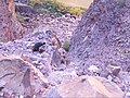 Rockslide-Escalante.JPG 2,576 × 1,932; 1.23 MB
-
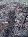 Slot Canyon-Escalante.JPG 1,932 × 2,576; 1.16 MB

