Category:Erve De Achterhoek (Colmschate)
Jump to navigation
Jump to search
| Object location | | View all coordinates using: OpenStreetMap |
|---|
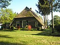
farmhouse in Deventer, Netherlands  | |||||
| Upload media | |||||
| Instance of | |||||
|---|---|---|---|---|---|
| Location | Colmschate, Deventer, Overijssel, Netherlands | ||||
| Street address |
| ||||
| Located on street |
| ||||
| Heritage designation |
| ||||
 | |||||
|
This is a category about rijksmonument number 12810
|
| Address |
|
Media in category "Erve De Achterhoek (Colmschate)"
The following 3 files are in this category, out of 3 total.
-
 Erve De Achterhoek -01.jpg 4,288 × 3,216; 2.99 MB
-
 Erve De Achterhoek -02.jpg 4,288 × 3,216; 2.96 MB
-
 Vooraanzicht - Colmschate - 20047185 - RCE.jpg 1,200 × 811; 255 KB

