Category:Erbeskopfturm
Jump to navigation
Jump to search
| Object location | | View all coordinates using: OpenStreetMap |
|---|
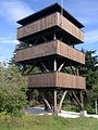
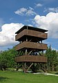
observation tower on Erbeskopf mountain  | |||||
| Upload media | |||||
| Instance of | |||||
|---|---|---|---|---|---|
| Made from material | |||||
| Location | Hilscheid, Bernkastel-Wittlich, Rhineland-Palatinate, Germany | ||||
| Height |
| ||||
 | |||||
Media in category "Erbeskopfturm"
The following 7 files are in this category, out of 7 total.
-
 2023 Erbeskopf, útsjochtoer.jpg 3,690 × 2,462; 3.12 MB
-
 Aussichtsturm Erbeskopf-01.jpg 3,240 × 4,320; 4.8 MB
-
 Aussichtsturm Erbeskopf-02.jpg 3,240 × 4,320; 4.9 MB
-
 Aussichtsturm Gipfel.jpg 1,944 × 2,592; 1.12 MB
-
 Erbeskopf-turm.jpg 406 × 561; 63 KB
-
 Erbeskopfturm Winter 2020.jpg 3,693 × 4,616; 3.19 MB
-
 Erbeskopfturm.jpg 3,664 × 5,233; 9.25 MB


