Category:Enceinte de Bazas
Jump to navigation
Jump to search
| Object location | | View all coordinates using: OpenStreetMap |
|---|
|
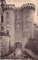
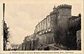
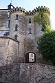
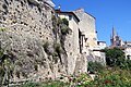
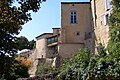
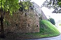
This building is inscrit au titre des monuments historiques de la France. It is indexed in the base Mérimée, a database of architectural heritage maintained by the French Ministry of Culture, under the reference PA00132528
|

 | |||||
| Upload media | |||||
| Instance of | |||||
|---|---|---|---|---|---|
| Location | Bazas, canton of Bazas | ||||
| Architectural style | |||||
| Heritage designation |
| ||||
 | |||||
Media in category "Enceinte de Bazas"
The following 13 files are in this category, out of 13 total.
-
 Bazas - porte de Gisquet 1a.jpg 442 × 695; 210 KB
-
 Bazas - porte de Gisquet 1b.jpg 457 × 696; 93 KB
-
 Bazas - porte de Gisquet 2.jpg 410 × 653; 129 KB
-
 Bazas - porte de Gisquet 3.jpg 664 × 1,034; 249 KB
-
 Bazas - porte de Gisquet 4.jpg 827 × 548; 185 KB
-
 Bazas - porte de Gisquet 5.jpg 1,000 × 647; 110 KB
-
 Bazas Porte du Gisquet.jpg 1,716 × 2,576; 1.54 MB
-
 Bazas Poterne Brèche.jpg 1,716 × 2,576; 1.56 MB
-
 Bazas Remparts 01.jpg 2,576 × 1,716; 1.7 MB
-
 Bazas Remparts 02.jpg 2,576 × 1,716; 1.57 MB
-
 Bazas Remparts Tourny.jpg 2,576 × 1,716; 1.52 MB
-
 Bazas-Porte du Gisquet-1846.png 800 × 506; 185 KB
-
 Bazas-Porte du Gisquet-1863.png 507 × 800; 116 KB


